Duras, Lot-et-Garonne
| Duras | ||
|---|---|---|
|
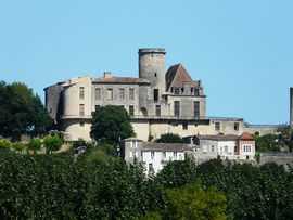
The château in Duras | ||
| ||
 Duras | ||
|
Location within Aquitaine region  Duras | ||
| Coordinates: 44°40′37″N 0°11′01″E / 44.6769°N 0.1836°ECoordinates: 44°40′37″N 0°11′01″E / 44.6769°N 0.1836°E | ||
| Country | France | |
| Region | Aquitaine | |
| Department | Lot-et-Garonne | |
| Arrondissement | Marmande | |
| Canton | Duras | |
| Area1 | 20.17 km2 (7.79 sq mi) | |
| Population (2010)2 | 1,316 | |
| • Density | 65/km2 (170/sq mi) | |
| INSEE/Postal code | 47086 / 47120 | |
| Elevation |
28–128 m (92–420 ft) (avg. 100 m or 330 ft) | |
|
1 French Land Register data, which excludes lakes, ponds, glaciers > 1 km² (0.386 sq mi or 247 acres) and river estuaries. 2 Population without double counting: residents of multiple communes (e.g., students and military personnel) only counted once. | ||

Duras is a commune in the Lot-et-Garonne department in south-western France.
The town is traversed by the Dropt river.
Notable people
- David Hume of Godscroft (1558-1629), Scottish historian and philosopher, was the pastor in Duras 1604-1614.
- The writer Marguerite Donnadieu (1914–1996) took the pseudonym "Marguerite Duras" in 1943, after this village, where her father's house was located.
Sister cities
Duras is twinned with the following cities:
-
.svg.png) Sint-Truiden, Belgium
Sint-Truiden, Belgium
See also
| Wikimedia Commons has media related to Duras, Lot-et-Garonne. |
- Communes of the Lot-et-Garonne department