Duquette, Minnesota
| Duquette, Minnesota | |
|---|---|
| Unincorporated community | |
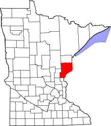
 Duquette, Minnesota Location of the community of Duquette | |
| Coordinates: 46°22′11″N 92°33′12″W / 46.36972°N 92.55333°WCoordinates: 46°22′11″N 92°33′12″W / 46.36972°N 92.55333°W | |
| Country | United States |
| State | Minnesota |
| County | Pine |
| Township | Kerrick Township and Nickerson Township |
| Elevation | 1,145 ft (349 m) |
| Population | |
| • Total | 70 |
| Time zone | Central (CST) (UTC-6) |
| • Summer (DST) | CDT (UTC-5) |
| ZIP code | 55756 or 55712 |
| Area code(s) | 218 |
| GNIS feature ID | 642988[1] |
Duquette is an unincorporated community in Pine County, Minnesota, United States; located along the Willow River.
State Highway 23 (MN 23) serves as a main route in the community. The Nemadji State Forest is nearby.
Duquette is located along the boundary line between Kerrick Township and Nickerson Township. The communities of Nickerson, Kerrick, and Holyoke are all near Duquette.
Community
Duquette is an unincorporated community in northern Pine County. Local businesses include the Duquette General Store and the Duquette Bar. Nearby is the Duquette Airport, a private, 1/4 mile grass airstrip, owned by Dick Hendrickson.
Duquette is the home of Jackie Berger Park; which includes campsites, ballfield, pavilion, tennis court, and fishing in the Willow River. A parking field for snowmobiles, offroad motorcycles or ATV's abuts the park.
History
Duquette is located along the BNSF Railway on what was at one time the Great Northern Railway. It was built on an early Indian village site located at the southern terminus of the Willow–Nemadji Portage; the first European settlers were French Canadians, among them was the entrepreneur Frank Duquette, who built a sawmill and store. Originally the village was named Kerrick until the Great Northern Railway depot was moved three miles south, keeping that name, and for a period Duquette was called Old Kerrick, the new site being called New Kerrick; the names were corrected when the Duquette post office was established in 1905.
References
- Rand McNally Road Atlas – 2007 edition – Minnesota entry
- Official State of Minnesota Highway Map – 2011/2012 edition
| |||||||||||||||||||||||||||||
