Dunkirk, Kent
| Dunkirk | |
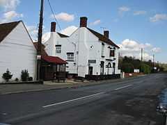 The Red Lion Inn, Dunkirk |
|
 Dunkirk |
|
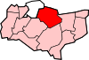
| District | Swale |
|---|---|
| Shire county | Kent |
| Region | South East |
| Country | England |
| Sovereign state | United Kingdom |
| Police | Kent |
| Fire | Kent |
| Ambulance | South East Coast |
| EU Parliament | South East England |
| UK Parliament | Canterbury |
Coordinates: 51°17′29″N 0°58′49″E / 51.2915°N 0.9804°E
Dunkirk is a village and civil parish between Faversham and Canterbury in southeast England. It lies on the Canterbury Road between Boughton under Blean and Harbledown.[1]
Toponymy
The origin of the village's name is still not very clear, but it is understood to come from a house called "Dunkirk", lived in by a Fleming from Dunkerque on the border between France and Belgium.
History
In 1800, according to Edward Hasted, the village was once part of the king's antient forest of Blean in the 'hundred of Westgate'.[1]
Dunkirk's main claim to fame is that in 1838 it was the scene of the last armed rising on British soil, the Battle of Bossenden Wood to the north of the village.[2]
In 2011, the villages had an official opening of their replacement Village Hall. £230,000 was raised to pay for the new hall.[3]
References
- ↑ 1.0 1.1 Hasted, Edward (1800). "Parishes". The History and Topographical Survey of the County of Kent (Institute of Historical Research) 9: 2–7. Retrieved 12 February 2014.
- ↑ Reay, B (1 October 1990). The last rising of the agricultural labourers: rural life and protest in nineteenth-century England. Oxford Clarendon Press. p. 85. ISBN 0-19-820187-7.
- ↑ "Villagers celebrate official opening of finished new hall". canterburytimes.co.uk. 16 September 2011. Retrieved 20 February 2014.
External links
![]() Media related to Dunkirk, Kent at Wikimedia Commons
Media related to Dunkirk, Kent at Wikimedia Commons