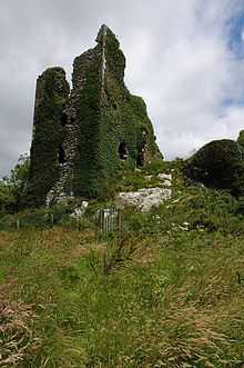
Dunhill, County Waterford
| Dunhill Dún Aill | |
|---|---|
| Village | |
 Dunhill Location in Ireland | |
| Coordinates: 52°10′22″N 7°15′44″W / 52.172665°N 7.262138°WCoordinates: 52°10′22″N 7°15′44″W / 52.172665°N 7.262138°W | |
| Country |
|
| Province | Munster |
| County | County Waterford |
| Time zone | WET (UTC+0) |
| • Summer (DST) | IST (WEST) (UTC-1) |
Dunhill (Irish:Dún Aill) is a town in County Waterford, Ireland.[1] The town comprises a church, a primary school, a parish hall, a public house and shop.[2] An enterprise park called Dunhill Ecopark was established in 2000 by members of the Dunhill community.[3]
Sacred Heart is the third church to have been built on the current site. The first structure was erected in 1798 after an old building in the townland of Shanaclune was abandoned.[2]
Education
There is an "Eco park"[4] for adult education as well as a National School. The ruins of Dunhill Castle are nearby.[5]
Sport
There is a GAA pitch adjacent to the "Eco park". The Dunhill GAA club enters teams in both GAA codes each year, which includes two adult hurling teams and one adult Gaelic football team.
Archaeology

The ruins of Dunhill Castle (tower house) is situated on a rock outcrop south of the village. The castle was owned by John Power in 1641 and traditionally it is thought to be an ancient stronghold which fell to Oliver Cromwell in the 17th century.[6]
Additional archaeological sites in the area include an earthwork, font, megalithic tomb, and 2 ringforts.[7]
External Links
References
- ↑ "Online Map Viewer". Ordnance Survey Ireland. Retrieved 15 January 2015.
- ↑ 2.0 2.1 Power, Frank. "Historical Dunhill Landmarks". Dunhill & Fenor Parish. Retrieved 15 January 2015.
- ↑ "Dunhill Ecopark". Retrieved 16 January 2015.
- ↑ Dunhill Ecopark website
- ↑ LookaroundIreland.com: Dunhill Castle
- ↑ "Archaeological Survey Database SMR WA025-045001". National Monuments Service. Retrieved 15 January 2015.
- ↑ "Archaeological Survey Database". National Monuments Service. Retrieved 15 January 2015.
| ||||||||||||||||||||||
