Dunai, Nepal
| Dunai दुनै | |
|---|---|
| Village development committee | |
|
Dunai, Dolpa, Nepal | |
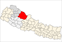
 Dunai Location in Nepal | |
| Coordinates: 28°56′N 82°54′E / 28.933°N 82.900°ECoordinates: 28°56′N 82°54′E / 28.933°N 82.900°E | |
| Country |
|
| Zone | Karnali Zone |
| District | Dolpa District |
| Population (1991) | |
| • Total | 1,773 |
| Time zone | Nepal Time (UTC+5:45) |
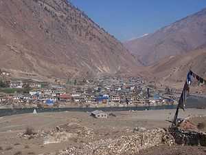
Dunai is the district headquarters of Dolpa District in Nepal. The town is situated on the banks of the Thuli Bheri River at about 2,000 metres (6,562 ft) elevation.
The 1991 Nepal census counted 1,773 persons in 334 households.[1]
Dunai has one FM radio station: Radio Dolpa F.M. 101.4 MHz. This is a Community radio Station. one Hospital: District Hospital This is a 15 bed Hospital. one Campus: Dolpo Campus This is a Affiliated with TU Education. one +2: Sarswoti Higher Secondary School This is a HSEB Morning. one Library: Dunai Community Library This is a Community Learning Center.
Dolpa Airport is 10 kilometres (6 mi) WNW of the town with flights to Nepalgunj, Surkhet and Pokhara.
References
- ↑ "Nepal Census 2001". Nepal's Village Development Committees. Digital Himalaya. Retrieved 3 September 2008.
| |||||||||||||