Dumbleyung Lake
| Dumbleyung Lake | |
|---|---|
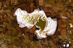 View from space | |
| Coordinates | 33°20′00″S 117°39′00″E / 33.33333°S 117.65000°ECoordinates: 33°20′00″S 117°39′00″E / 33.33333°S 117.65000°E |
| Type | salt lake |
| Primary inflows | Coblinine River System |
| Basin countries | Australia |
| Max. length | 13 km |
| Max. width | 6.5 km |
| Surface area | 52 square kilometres (20 sq mi) |
| Average depth | 2.35 metres (8 ft) (September mean) |
| Max. depth | 4.57 metres (15 ft) (overflowing) |
| Surface elevation | 255 metres (837 ft) |
Dumbleyung Lake, also widely known as Lake Dumbleyung, is a salt lake in Western Australia. It is located at 33°20′00″S 117°39′00″E / 33.33333°S 117.65000°E, in the Great Southern region of Western Australia. With a length of 13 kilometres (8 mi) and a width of 6.5 kilometres (4 mi), it covers a total area of 52 square kilometres (20 sq mi).
The explorers Henry Landor and Henry Maxwell Lefroy are usually credited with the discovery of Dumbleyung Lake, although it appears to have been shown on a map in 1839 with the name Kondening Lake. Grazing leases around the lake were first granted to George Kersley in 1875.
Dumbleyung Lake received world recognition when Donald Campbell broke the world water speed record on it on 31 December 1964, travelling at 444.66 km/h (276.3 mph) in his boat Bluebird K7. A granite memorial to Campbell can be seen at Pussy Cat Hill, a prominent feature and vantage point to view the entire lake area.[1]
In recent times, the increased soil salination has made the area unsuitable for grazing. Today the lake is mainly used for aquatic recreation. Despite the extreme salinity of the lake, it provides a habitat for many varieties of water birds, and since 1963 has been protected by the Dumbleyung Lake Nature Reserve.
The lake is recognised as a DIWA wetland as it is a drought refuge for waterbirds and a moulting area for the Australian Shelduck.[2]
References
- ↑ http://www.dumbleyung.wa.gov.au/
- ↑ "DIWA information Sheet". 2010. Retrieved 2010-06-05.