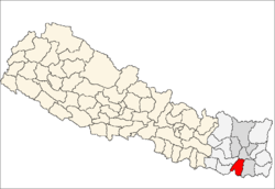
Dumaraha
| Dumaraha डुम्राहा | |
|---|---|
| Village development committee | |
 Dumaraha Location in Nepal | |
| Coordinates: 26°38′N 87°08′E / 26.64°N 87.14°ECoordinates: 26°38′N 87°08′E / 26.64°N 87.14°E | |
| Country |
|
| Zone | Kosi Zone |
| District | Sunsari District |
| Population (1991) | |
| • Total | 13,215 |
| Time zone | Nepal Time (UTC+5:45) |
Dumaraha is a village development committee in Sunsari District in the Kosi Zone of south-eastern Nepal. There are 9 wards and main villages of Dumaraha are Arta, Sitpur, Marchaya, Kansamadan, Bankulwa etc. At the time of the 1991 Nepal census it had a population of 13,215 people living in 2426 individual households. There are some community schools like Shree Tribhuvan Secondary School, Shera Primary School, Thule Mohor Primary School, Sanischare Secondary School. There are also some private schools like Siddhartha Shikshya Sadan , M.S. Standard English School, Herculus English School etc. There is Shera River flowing by the side of Ramdhuni forest past the Arta villgae. It is easy to reach Ramdhuni Temple from here. Though the village is well connected by road, electricity but development of infrastructure is not rapid as expected. [1]
References
- ↑ "Nepal Census 2001". Nepal's Village Development Committees. Digital Himalaya. Retrieved 2 December 2008.
