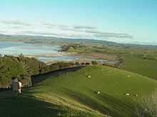
Duder Regional Park

Duder Regional Park is a 162 ha (400 acres) regional park situated on the coast to the east of Auckland city, New Zealand.
History
The park was created in 1995 after the sale of the land by the Duder family to the Auckland Regional Council.[1][2] Prior to the sale the land had been farmed by descendants of Thomas Duder for about 130 years. The land was purchased in 1866 from the original Maori owners Ngai Tai who had historically built a pa on the headland.
An extra 13.7 ha was added in 2010 to prevent coast development obstructing views from the park.[3]

Description
The park is a working farm bounded to the west by Duders Beach. It is situated on a headland and offers commanding views of the Hauraki Gulf. There is limited native bush as most of the land is grassed. There are no designated picnic areas and facilities are limited.
Small numbers of the endangered tuturiwhatu (New Zealand dotterel) breed on shell banks south of the park. This area is not accessible to the public.
References
- ↑ Duder - Auckland Regional Council
- ↑ Duder's Beach / Umupuia - Pohutukawa Coast
- ↑ "More land secured for Duder Regional Park". ARC. 30 April 2010. Retrieved 1 May 2010.
External links
| Wikimedia Commons has media related to Category:Duder Regional Park. |
- Auckland Regional Council Management plan - Gives descriptions of geology of Duder park, Waiheke and Hunua etc
Coordinates: 36°54′22″S 175°05′03″E / 36.9061°S 175.0841°E