Duékoué
| Duékoué | |
|---|---|
| Town | |
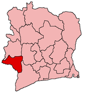
 Duékoué Location in Côte d'Ivoire | |
| Coordinates: 6°44′N 7°21′W / 6.733°N 7.350°WCoordinates: 6°44′N 7°21′W / 6.733°N 7.350°W | |
| Country |
|
| Region | Moyen-Cavally |
| Department | Duékoué Department |
| Time zone | GMT (UTC+0) |
Duékoué (French: [dwekwe]) is a town in Duékoué Department of Moyen-Cavally Region, Côte d'Ivoire.
History
At least 800 people were killed in Duékoué on March 29, 2011 during the fierce fighting by the frci as part of the 2010–2011 Ivorian crisis.[1]
Climate
Köppen-Geiger climate classification system classifies its climate as tropical wet and dry (Aw).[2]
| Climate data for Duékoué | |||||||||||||
|---|---|---|---|---|---|---|---|---|---|---|---|---|---|
| Month | Jan | Feb | Mar | Apr | May | Jun | Jul | Aug | Sep | Oct | Nov | Dec | Year |
| Average high °C (°F) | 33.2 (91.8) |
33.5 (92.3) |
33.1 (91.6) |
32.5 (90.5) |
31.8 (89.2) |
29.9 (85.8) |
28.2 (82.8) |
28 (82) |
29.2 (84.6) |
30.3 (86.5) |
31.4 (88.5) |
31.8 (89.2) |
31.08 (87.9) |
| Daily mean °C (°F) | 25.9 (78.6) |
26.9 (80.4) |
27.1 (80.8) |
26.9 (80.4) |
26.6 (79.9) |
25.4 (77.7) |
24.1 (75.4) |
24 (75) |
24.8 (76.6) |
25.4 (77.7) |
25.8 (78.4) |
25.3 (77.5) |
25.68 (78.2) |
| Average low °C (°F) | 18.6 (65.5) |
20.3 (68.5) |
21.1 (70) |
21.4 (70.5) |
21.5 (70.7) |
21 (70) |
20.1 (68.2) |
20.1 (68.2) |
20.5 (68.9) |
20.5 (68.9) |
20.3 (68.5) |
18.9 (66) |
20.36 (68.66) |
| Average precipitation mm (inches) | 14 (0.55) |
55 (2.17) |
103 (4.06) |
132 (5.2) |
149 (5.87) |
207 (8.15) |
125 (4.92) |
181 (7.13) |
290 (11.42) |
177 (6.97) |
56 (2.2) |
17 (0.67) |
1,506 (59.31) |
| Source: Climate-Data.org (altitude: 231m)[2] | |||||||||||||
References
- ↑ "Fighting in Ivory Coast town kills at least 800 people, Red Cross says". BNO News. Retrieved 2 April 2011.
- ↑ 2.0 2.1 "Climate: Duekoue - Climate graph, Temperature graph, Climate table". Climate-Data.org. Retrieved 2014-01-06.
| |||||||||||||||||||||||||