Dry Creek (Mokelumne River)
| Dry Creek | |
| River | |
| Country | United States |
|---|---|
| State | California |
| Regions | Amador County, Sacramento County, San Joaquin County |
| Source | |
| - coordinates | 38°28′13″N 120°48′40″W / 38.47028°N 120.81111°W |
| Mouth | Mokelumne River [1] |
| - elevation | 13 ft (4 m) |
| - coordinates | 38°13′55″N 121°24′42″W / 38.23194°N 121.41167°WCoordinates: 38°13′55″N 121°24′42″W / 38.23194°N 121.41167°W |
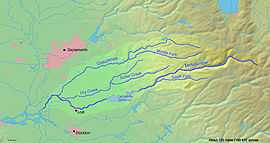 Map of the Mokelumne River watershed
| |
Dry Creek is a 47.1-mile-long (75.8 km)[2] stream in northern California which runs from the Sierra Nevada to the Mokelumne River west of Galt.
Tributaries
- North Fork Dry Creek
- South Fork Dry Creek
- Sutter Creek
- Jackson Creek
See also
References
- ↑ U.S. Geological Survey Geographic Names Information System: Dry Creek
- ↑ U.S. Geological Survey. National Hydrography Dataset high-resolution flowline data. The National Map, accessed March 11, 2011
| ||||||||||||||