Dropull
| Dropull | |
|---|---|
| Municipality | |
|
Dawn near Jorgucat | |
 Dropull | |
| Coordinates: 39°59′N 20°14′E / 39.983°N 20.233°ECoordinates: 39°59′N 20°14′E / 39.983°N 20.233°E | |
| Country |
|
| County | Gjirokastër |
| Area | |
| • Total | 448.25 km2 (173.07 sq mi) |
| Population (2011) | |
| • Total | 3,503 |
| • Density | 7.8/km2 (20/sq mi) |
| Time zone | CET/CEST (UTC+1/+2) |
| Car plates | GJ |

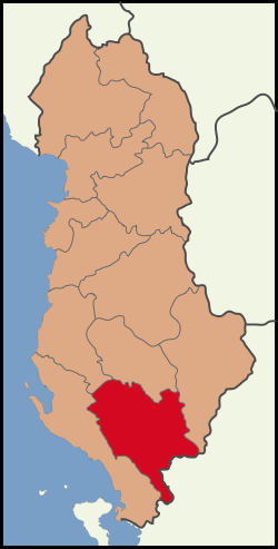
Dropull (Albanian: Dropulli; Greek: Δρόπολις, Dropolis) is a future municipality and a predominantly Greek-inhabited region in Gjirokastër County, in southern Albania. The region stretches from south of the city of Gjirokastër to the Greek–Albanian border, along the Drinos river. The region's villages are part of the Greek "minority zone" recognized by the Albanian government, in which live majorities of ethnic Greeks.[1] The municipality Dropull will be created in 2015 by the merger of the present municipalities Dropull i Poshtëm, Dropull i Sipërm and Pogon. The seat of the municipality will be the village Sofratikë.[2] The total population is 3,503 (2011 census), in a total area of 448.25 km2.[3]
History
During the Middle Helladic period (2100-1550 BC), a double tumulus was excavated, in Vodhinë, with strong similarities to the grave circles at Mycenae, showing a common ancestral link with the Myceneans of southern Greece.[4] In classical antiquity, the area was inhabited by the Greek tribe of the Chaonians.
From the Roman period there was a fortified settlement named Hadrianoupolis in the region, named after the Roman emperor Hadrian. The settlement was built on a strategic spot in the valley of the river Drinos near the modern village of Sofratika, 11 kilimetres south of Gjirokastër. During the 6th century the Byzantine emperor Justinian I, as part of his fortification plans against barbarian invasions, moved the settlement 4 kilometers southeast in the modern village of Peshkëpi, in order to gain a more secure position. The city is also referred in Byzantine sources as Ioustinianoupolis. Today, ruins of the fortifications are still visible, as are the aqueduct and a medieval Orthodox Christian church.[5]
During the 11th century the city was named Dryinoupolis, a name possibly deriving from its former name or from the nearby river. It was also, from the 5th century, the see of a bishopric (initially part of the Diocese of Nicopolis, Naupactus and then Ioannina).
The bishopric of Dryinoupolis included the region of modern southwest Albania and from the 16th century its center was Gjirokastër.[6] At the end of the 19th century, many inhabitants migrated to the United States.[7]
Villages

Some of the villages of the region are:
|
|
Notable people
- Cleoniki Deliyiorgi, Miss Shqipëria 2012 and Miss Globe International 2012.[8]
- Spiro Ksera, politician.
- Lefter Millo, famous soccer player, capped with Albania.
- Vasilios Sahinis, leader of the Northern Epirote Liberation Organization.
- Kosmas Thesprotos, scholar.
- Tasos Vidouris, poet.
See also
References
- ↑ "Second Report Submitted by Albania Pursuant to Article 25, Paragraph 1 of the Framework Convention for the Protection of National Minorities".
- ↑ Law nr. 115/2014
- ↑ Interactive map administrative territorial reform
- ↑ Komita, Nuobo (1982). "The Grave Cicles at Mycenae and the Early Indo-Europeans". Research Reports of Ikutoku Tech. Univ. (A-7): 59–70.
- ↑ Epirus, 4000 years of Greek history and civilization. M. V. Sakellariou. Ekdotike Athenon, 1997. ISBN 960-213-371-6, p. 154, 191
- ↑ Albania's captives. Pyrrhus J. Ruches. Argonaut, 1965, p/
- ↑ Religion in Post-Communist Albania. Muslims, Christians and the idea of ‘culture’ in Devoll, Southern Albania. Gilles de Rapper. p. 7
- ↑ "Miss Globe International 2012: η Κλεονίκη Δεληγιώργη". politikanet.gr. Retrieved 27 January 2014.
| |||||||||||||||||||||||||||||||||||||
| ||||||||||||||||