Droiturier
| Droiturier | |
|---|---|
|
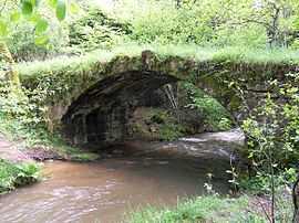
The Romanesque bridge in Droiturier | |
 Droiturier | |
|
Location within Auvergne region  Droiturier | |
| Coordinates: 46°13′53″N 3°43′09″E / 46.2314°N 3.7192°ECoordinates: 46°13′53″N 3°43′09″E / 46.2314°N 3.7192°E | |
| Country | France |
| Region | Auvergne |
| Department | Allier |
| Arrondissement | Vichy |
| Canton | Lapalisse |
| Intercommunality | Pays de Lapalisse |
| Government | |
| • Mayor (2008–2014) | Rolland Billaud |
| Area1 | 22.07 km2 (8.52 sq mi) |
| Population (2008)2 | 348 |
| • Density | 16/km2 (41/sq mi) |
| INSEE/Postal code | 03105 / 03120 |
| Elevation |
314–472 m (1,030–1,549 ft) (avg. 450 m or 1,480 ft) |
|
1 French Land Register data, which excludes lakes, ponds, glaciers > 1 km² (0.386 sq mi or 247 acres) and river estuaries. 2 Population without double counting: residents of multiple communes (e.g., students and military personnel) only counted once. | |
Droiturier is a commune in the Allier department in central France.
Population
| Historical population | ||
|---|---|---|
| Year | Pop. | ±% |
| 1962 | 415 | — |
| 1968 | 434 | +4.6% |
| 1975 | 392 | −9.7% |
| 1982 | 395 | +0.8% |
| 1990 | 433 | +9.6% |
| 1999 | 385 | −11.1% |
| 2008 | 348 | −9.6% |
See also
References
| Wikimedia Commons has media related to Droiturier. |