Drava
| Drava | |
| Drau, Drave, Dráva | |
| River | |
| Countries | Italy, Austria, Slovenia, Croatia, Hungary |
|---|---|
| Tributaries | |
| - left | Wąsawa |
| Cities | Lienz, Spittal an der Drau, Villach, Ferlach, Dravograd, Vuzenica, Muta, Ruše, Maribor, Ptuj, Ormož, Varaždin, Osijek, Barcs |
| Source | North of the Neunerkogel over the Toblacher Feld |
| - location | Toblach, South Tyrol, Italy |
| - elevation | 1,450 m (4,757 ft) |
| - coordinates | 46°43′9″N 12°15′16″E / 46.71917°N 12.25444°E |
| Mouth | Danube near Osijek |
| - coordinates | 45°32′38″N 18°55′31″E / 45.54389°N 18.92528°ECoordinates: 45°32′38″N 18°55′31″E / 45.54389°N 18.92528°E |
| Length | 707 km (439 mi) |
| Basin | 40,120 km2 (15,490 sq mi) |
| Discharge | |
| - average | 670 m3/s (23,661 cu ft/s) |
 Map of Drava River
| |
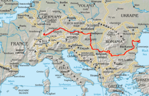
The Drava[1] (German: Drau; Hungarian: Dráva) or Drave[1] is a river in southern Central Europe, which is an important tributary of the Danube. Its source is in Italian South Tyrol, at the drainage divide of Toblach (Dobbiaco) in the Puster Valley. It flows eastwards through East Tirol and Carinthia in Austria into Slovenia for 142 kilometres (88 mi)[2] and then southeast, passing through Croatia and forming most of the border between Croatia and Hungary, before it joins the Danube near Osijek.
Overview
In ancient times the river was known as Dravus. The name is most likely of Celtic or Illyrian origin (see Old European hydronymy). The river gives its name to the dravite species of tourmaline.
The Drava (along with one of its tributaries the Slizza) and the Spöl are the only two rivers originating in Italy that belong to the Danube drainage basin. It is the fourth longest Danube tributary.[3] The Gail in Austria, the Meža and Dravinja in Slovenia, and the Bednja in Croatia from the south, as well as the Gurk and the Lavant in Austria, and the Mur (near Legrad) in Croatia from the north are its main tributaries.
Course
The Drava flows through Innichen/San Candido in Italy, Lienz, Spittal an der Drau, Villach, and Ferlach in Austria, Dravograd, Vuzenica, Muta, Ruše, Maribor, Ptuj, and Ormož in Slovenia, Varaždin, Belišće and Osijek in Croatia, and Barcs in Hungary. It is navigable for about 90 kilometres (56 mi) from Čađavica in Croatia to its mouth.[2]
The hydrological parameters of Drava are regularly monitored in Croatia at Botovo, Terezino Polje, Donji Miholjac and Osijek.[4]
References
- ↑ 1.0 1.1 Utrata Fachwörterbuch: Geographie - Englisch-Deutsch/Deutsch-Englisch by Jürgen Utrata (2014). Retrieved 10 Apr 2014.
- ↑ 2.0 2.1 "Reke, dolge nad 25 km, in njihova padavinska obmocja" [Rivers, longer than 25 km, and their catchment areas] (in Slovene and English). Statistical Office of the Republic of Slovenia. 2002.
- ↑ Klement Tockner, Urs Uehlinger, Christopher T. Robinson (2009), Rivers of Europe, Academic Press, no nr., ISBN 978-0-12-369449-2
- ↑ "Daily hydrological report". State Hydrometeorological Bureau of the Republic of Croatia. Retrieved 2010-09-09.
External links
![]() Media related to Drava at Wikimedia Commons
Media related to Drava at Wikimedia Commons
- DrauDrava - old river and new sounds
- Condition of Drava in various locations in Slovenia:
- Črneče - graphs, in the following order, of water level, flow and temperature data for the past 30 days (taken in Črneče by ARSO)
- Ptuj - graphs, in the following order, of water level, flow and temperature data for the past 30 days (taken in Ptuj by ARSO)
- Borl - graphs, in the following order, of water level, flow and temperature data for the past 30 days (taken in Borl by ARSO)
Gallery
| Wikimedia Commons has media related to Drava. |
-
.jpeg)
Drau at Villach
-

Drau near Rosegg
-

Drava at Maribor
-

River Drava near Klagenfurt
-

Drava at Ptuj
References
| ||||||||||||||||||
| ||||||||||||||||||||||||||||||||||||
| |||||||||||||||||||||||||