Dove Creek, Colorado
| Town of Dove Creek, Colorado | |
|---|---|
| Statutory Town | |
|
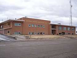
Dolores County Courthouse in Dove Creek, Colorado | |
| Nickname(s): Pinto Bean Capital of the World | |
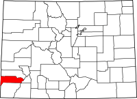
 Location in Dolores County and the State of Colorado | |
| Coordinates: 37°46′00″N 108°54′23″W / 37.766665°N 108.906297°WCoordinates: 37°46′00″N 108°54′23″W / 37.766665°N 108.906297°W[1] | |
| Country |
|
| State |
|
| County | Dolores County Seat[2] |
| Incorporated | June 15, 1939[3] |
| Government | |
| • Type | Statutory Town[2] |
| Area | |
| • Total | 0.5 sq mi (1.4 km2) |
| • Land | 0.5 sq mi (1.4 km2) |
| • Water | 0 sq mi (0 km2) |
| Elevation[4] | 6,844 ft (2,086 m) |
| Population (2009)[5] | |
| • Total | 689 |
| • Density | 1,378/sq mi (498.6/km2) |
| Time zone | MST (UTC-7) |
| • Summer (DST) | MDT (UTC-6) |
| ZIP code[6] | 81324 |
| Area code(s) | 970 |
| INCITS place code | 0821265 |
| GNIS feature ID | 0176436 |
The Town of Dove Creek is the Statutory Town that is the county seat and the most populous municipality of Dolores County, Colorado, United States.[7] Dove Creek is the self-proclaimed Pinto Bean Capital of the World. The estimated population in 2009, according to the American Community Survey was 689.[5]
Geography
Dove Creek is located at 37°45′58″N 108°54′20″W / 37.76611°N 108.90556°W (37.765994, -108.905691).[8]
According to the United States Census Bureau, the town has a total area of 0.5 square miles (1.3 km2), all of it land.
The town is located on US 491 (formerly US 666) at the crossing of Dove Creek, the town's namesake. Dove Creek flows south to Cross Canyon, Montezuma Creek, Utah, and the San Juan River. The town is located on the northern portion of the Great Sage Plain, a large plateau covered in desert lands, bounded by the La Plata Mountains, Mesa Verde National Park, the La Sal Mountains, and the Abajo Mountains, and cut by dozens of deep canyons, which was and is a productive agricultural region. The plateau is dotted with numerous ruins of the Anasazi and other ancient people who took advantage of good soils and terrain, even with limited water resources.
The Dolores County Courthouse, built in 1957, replaces a temporary courthouse in the town used after voters of the county moved the county seat from Rico, Colorado to Dove Creek in 1947, reflecting a shift in the original mining-oriented make-up of the county's population to the current situation in which farmers and a few ranchers outnumber the mountain-dwellers in the old mining districts of the eastern end of Dolores County. The courthouse is adjacent to Dolores County High School, and is part of the old business district located north of US 491; most business is now located on US 491 as it angles through the town from ESE to WNW. A regional landmark is the large concrete bean elevator located on the west edge of town, near the Dolores County Industrial Park.
SH 141 intersects with US 491 just west of town, and provides access to the Paradox Valley, Nucla-Naturita, and the uranium mining and industrial area of Montrose County, Colorado, and Grand County, Utah.
Demographics
As of the census[9] of 2000, there were 698 people, 285 households, and 202 families residing in the town. The population density was 1,322.5 people per square mile (508.5/km²). There were 326 housing units at an average density of 617.7 per square mile (237.5/km²). The racial makeup of the town was 96.28% White, 1.86% Native American, 0.29% from other races, and 1.58% from two or more races. Hispanic or Latino of any race were 3.87% of the population.
There were 285 households out of which 31.2% had children under the age of 18 living with them, 54.4% were married couples living together, 13.0% had a female householder with no husband present, and 28.8% were non-families. 26.0% of all households were made up of individuals and 14.4% had someone living alone who was 65 years of age or older. The average household size was 2.45 and the average family size was 2.93.
In the town the population was spread out with 26.6% under the age of 18, 7.9% from 18 to 24, 24.4% from 25 to 44, 22.3% from 45 to 64, and 18.8% who were 65 years of age or older. The median age was 39 years. For every 100 females there were 97.2 males. For every 100 females age 18 and over, there were 91.0 males.
The median income for a household in the town was $27,500, and the median income for a family was $32,813. Males had a median income of $28,333 versus $17,500 for females. The per capita income for the town was $13,015. About 8.9% of families and 12.3% of the population were below the poverty line, including 9.9% of those under age 18 and 16.0% of those age 65 or over.
The development of the Dolores County Industrial Park west of Dove Creek, the site of a biodiesel plant which began construction in 2007, currently produces food-grade vegetable oil from sunflowers, safflower, and canola grown in the Dove Creek area, and will ultimately produce biodiesel, is an attempt to add value and stabilize markets for produce grown locally. The industrial park is also home to the community's first ready-mix plant in many decades, and other businesses. New housing developments have been permitted and platted in the Dove Creek area, anticipating growth due to efforts like this. On the eastern edge of the town is the headquarters and facility of Adobe Milling, a company marketing various locally-grown beans and other traditional southwestern foods.
Major employers in the town include the county government and school district, and various other government agencies. Most businesses in town support agricultural operations; some provide transportation services for highway users.
History
There are several areas prehistoric and historic sites listed on the Colorado State Register of Historic Properties:[10]
- Brewer Archaeological District of two large prehistoric settlement sites: Brewer Mesa Pueblo (11th century) and Brewer Canyon Pueblo (13th century).
- P.R. Butt & Sons Building built in 1914 is generally considered the town's second building.
- Glade Ranger Station, dated before AD 1910.
See also
- Outline of Colorado
- State of Colorado
- Colorado cities and towns
- Colorado municipalities
- Colorado counties
- Colorado cities and towns
- Old Spanish National Historic Trail
- Pinto bean
References
- ↑ "2014 U.S. Gazetteer Files: Places". United States Census Bureau. July 1, 2014. Retrieved January 5, 2015.
- ↑ 2.0 2.1 "Active Colorado Municipalities". State of Colorado, Department of Local Affairs. Retrieved 2007-09-01.
- ↑ "Colorado Municipal Incorporations". State of Colorado, Department of Personnel & Administration, Colorado State Archives. 2004-12-01. Retrieved 2007-09-02.
- ↑ "US Board on Geographic Names". United States Geological Survey. 2007-10-25. Retrieved 2008-01-31.
- ↑ 5.0 5.1 "Dove Creek town, Colorado". 2005-2009 American Community Survey 5-Year Estimates. U.S. Census Bureau. Retrieved 3 July 2011.
- ↑ "ZIP Code Lookup" (JAVASCRIPT/HTML). United States Postal Service. Retrieved September 8, 2007.
- ↑ "Find a County". National Association of Counties. Retrieved 2011-06-07.
- ↑ "US Gazetteer files: 2010, 2000, and 1990". United States Census Bureau. 2011-02-12. Retrieved 2011-04-23.
- ↑ "American FactFinder". United States Census Bureau. Retrieved 2008-01-31.
- ↑ National & State Registers for Dolores County, Colorado. Colorado Historical Society, Office of Archaeology and Historic Preservation. Retrieved 10-8-2011.
External links
| Wikimedia Commons has media related to Dove Creek, Colorado. |
| |||||||||||||||||