Doubs (river)
| Doubs | |
|---|---|
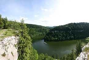
 The Doubs between Switzerland and France | |
| Origin |
Mouthe, Jura mountains 46°42′17″N 6°12′34″E / 46.70472°N 6.20944°E |
| Mouth |
Saône 46°54′3″N 5°1′27″E / 46.90083°N 5.02417°ECoordinates: 46°54′3″N 5°1′27″E / 46.90083°N 5.02417°E |
| Basin countries | France, Switzerland |
| Length | 453 kilometres (281 mi) |
| Source elevation | 937 m |
| Avg. discharge | 176 m³/s |
| Basin area | 7500 km² |
The Doubs (French pronunciation: [du]) is a 453 kilometres (281 mi) long river in eastern France and western Switzerland, left tributary of the Saône. Its source is near Mouthe in the western Jura mountains.
First it flows northeast, more or less along the French-Swiss border (forming the border for approx. 40 km). Near Montbéliard it turns southwest, until it flows into the river Saône in Verdun-sur-le-Doubs, approx. 20 km northeast of Chalon-sur-Saône. Its entire course resembles an inverted letter U, with the northeastern corner the only point at which the Doubs flows into Switzerland as far as Saint-Ursanne.
.jpg)
The Doubs flows through the following Departments of France, Cantons of Switzerland, and cities:
- Doubs (F): Pontarlier
- Neuchâtel (CH)
- Jura (CH): Saint-Ursanne
- Doubs (F): Montbéliard, Besançon
- Jura (F): Dole
- Saône-et-Loire (F): Verdun-sur-le-Doubs
Tributaries include:
- Loue
- Dessoubre
The river forms several lakes:
- Lac des Brenets (elevation 750 m)
- Lac de Moron (elevation 716 m)
- Lac de Biaufond (elevation 610 m)
See also
References
| Wikimedia Commons has media related to Doubs River. |
| Wikisource has the text of the 1911 Encyclopædia Britannica article Doubs (river). |