Don Juan Pond
| Don Juan Pond | |
|---|---|
 Satellite photo | |
| Location | Eastern Antarctica |
| Coordinates | 77°33′55″S 161°11′26″E / 77.56528°S 161.19056°ECoordinates: 77°33′55″S 161°11′26″E / 77.56528°S 161.19056°E |
| Type | hypersaline lake |
| Basin countries | (Antarctica) |
| Max. length | 300 m |
| Max. width | 100 m |
| Surface area | 0.03 km² |
| Water volume | 3000 m³ |
| Frozen | almost never |
| Islands | none |
| Settlements |
Vanda Station (14 km to the east) |
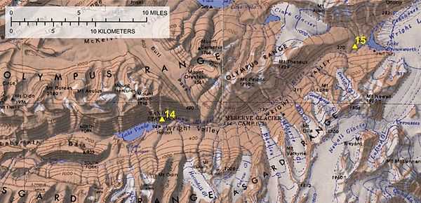
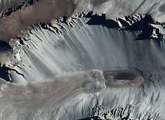
Don Juan Pond, also called Lake Don Juan, is a small and very shallow hypersaline lake in the west end of Wright Valley (South Fork), Victoria Land, Antarctica, 9 kilometres (5.6 mi) west from Lake Vanda. It is wedged between the Asgard Range in the south and the Dais in the north. On the west end there is a small tributary and a feature that has been described as a rock glacier. With a salinity level of over 40%, Don Juan Pond is the saltiest known body of water on Earth.[1][2]
Don Juan Pond was discovered in 1961. It was named for two helicopter pilots, Lt Don Roe and Lt John Hickey, who piloted the helicopter involved with the first field party investigating the pond. On that initial investigation, the temperature was −30 °C (−22 °F) and the water remained in a liquid state.
Salinity
Don Juan Pond is a shallow, flat-bottom, hyper-saline pond. It has greater salinity than the Dead Sea or even Lake Assal (Djibouti) (the same is true for Lake Vanda and perhaps other lakes in the McMurdo Dry Valleys). It is claimed that Don Juan Pond is over 18 times the ocean's salinity, compared to the Dead Sea at 9.6 times that of the ocean. The fact that it is the only one of the Antarctic hypersaline lakes that almost never freezes is an indication of its top rank in salinity among the world's lakes. It has been described as a groundwater discharge zone. The dominant ions in solution are calcium and chloride. The area around Don Juan Pond is covered with sodium chloride and calcium chloride salts that have been precipitated as the water evaporated. Area and volume of Don Juan Pond vary over time. According to the USGS topographical map published in 1977, the area was approximately 0.25 km2 (62 acres). However, in recent years the size of the pond has shrunk considerably. The maximum depth in 1993–1994 was described as "a foot deep" (30 cm). In January 1997, it was approximately 10 centimetres (3.9 in) deep; in December 1998 the pond was almost dry everywhere except for an area of a few tens of square meters. Most of the remaining water was in depressions around large boulders in the pond.[3]
The calculated composition for its water is CaCl2 3.72 mol/kg and NaCl 0.50 mol/kg, at the temperature of -51.8°C.[1] That would be equivalent to 413 g of CaCl2 and 29 g of NaCl per kg of water.
References
- ↑ 1.0 1.1 G.M. Marion (1997). "A theoretical evaluation of mineral stability in Don Juan Pond, Wright Valley, Victoria Land". Antarctic Science 9 (01): 92–9. doi:10.1017/S0954102097000114.
- ↑ "Don Juan Pond and Lake Vanda Photo Gallery by Suze at pbase.com".
- ↑ "Title unknown" (csv). McMurdo Dry Valleys Long-Term Ecological Research. Retrieved 2012-10-28.
Literature
- Yamagata, N., T. Torii, S. Murata. "Report of the Japanese summer parties in Dry Valleys, Victoria Land, 1963–65; V – Chemical composition of lake waters". Antarctic Record 29: 53–75.
External links
- Great Zoom into Don Juan Pond, Antarctica
- Siegel, B. Z.; McMurty, G.; Siegel, S. M.; Chen, J.; Larock, P. (30 August 1979). "Life in the calcium chloride environment of Don Juan Pond, Antarctica". Nature 280 (5725): 828–9. doi:10.1038/280828a0.
- McMurdo Dry Valleys MCM Lakes Data
- U.S. Geological Survey Geographic Names Information System: Don Juan Pond
- Don Juan Pond GigaPan picture