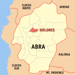
Dolores, Abra
| Dolores | ||
|---|---|---|
| Municipality | ||
| ||
 Map of Abra showing the location of Dolores | ||
.svg.png) Dolores Location within the Philippines | ||
| Coordinates: 17°38′48″N 120°42′39″E / 17.64667°N 120.71083°ECoordinates: 17°38′48″N 120°42′39″E / 17.64667°N 120.71083°E | ||
| Country | Philippines | |
| Region | Cordillera Administrative Region (CAR) | |
| Province | Abra | |
| District | Lone District of Abra | |
| Barangays | 15 | |
| Government[1] | ||
| • Mayor | Robert Victor G. Seares Jr. | |
| Area[2] | ||
| • Total | 47.45 km2 (18.32 sq mi) | |
| Population (2010)[3] | ||
| • Total | 11,499 | |
| • Density | 240/km2 (630/sq mi) | |
| Time zone | PST (UTC+8) | |
| ZIP code | 2801 | |
| Dialing code | 74 | |
| Income class | 5th class municipality | |
Dolores is a fifth class municipality in the province of Abra, Philippines. According to the 2010 census, it has a population of 11,499 people.[3]
The place was formerly called Bucao, named after the first Tingguian (Itneg) chieftain who settled in the place long before Spanish colonization. It was formerly part of the Municipality of Tayum. In 1882, upon the recommendation of the parish priest of Tayum, Fr. Pio Mercado, and the Teniente Bazar of Bucao, Don Ignacio Eduarte, Bucao was created as a separate pueblo. In 1885, Bucao was renamed Dolores, in honor to its patron saint, the Nuestra Señora delos Dolores (Our Lady Of Sorrows). The first gobernadorcillo of the town was Don Rosalio Eduarte.
Barangays
Dolores is politically subdivided into 15 barangays.[2]
| Barangay | Population (2007) |
Population (2010)[3] |
|---|---|---|
| Bayaan | |
|
| Cabaroan | |
|
| Calumbaya | |
|
| Cardona | |
|
| Isit | |
|
| Kimmalaba | |
|
| Libtec | |
|
| Lub-lubba | |
|
| Mudiit | |
|
| Namit-ingan | |
|
| Pacac | |
|
| Poblacion | |
|
| Salucag | |
|
| Talogtog | |
|
| Taping | |
|
Demographics
| Population census of Dolores | ||
|---|---|---|
| Year | Pop. | ±% p.a. |
| 1990 | 8,577 | — |
| 1995 | 9,560 | +2.05% |
| 2000 | 9,949 | +0.86% |
| 2007 | 10,787 | +1.12% |
| 2010 | 11,499 | +2.35% |
| Source: National Statistics Office[3] | ||
References
- ↑ "Official City/Municipal 2013 Election Results". Intramuros, Manila, Philippines: Commission on Elections (COMELEC). 11 September 2013. Retrieved 30 December 2013.
- ↑ 2.0 2.1 "Province: ABRA". PSGC Interactive. Makati City, Philippines: National Statistical Coordination Board. Retrieved 30 December 2013.
- ↑ 3.0 3.1 3.2 3.3 "Total Population by Province, City, Municipality and Barangay: as of May 1, 2010". 2010 Census of Population and Housing. National Statistics Office. Retrieved 30 December 2013.
External links
 |
San Juan |  | ||
| La Paz | |
Lagangilang | ||
| ||||
| | ||||
| Tayum | Lagangilang |
| ||||||||||||||
