Doi Inthanon
| Doi Inthanon | |
|---|---|
|
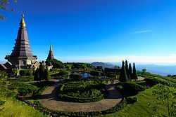
Naphamethinidon and Naphaphonphumisiri, two chedis near the summit of Doi Inthanon | |
| Elevation | 2,565 m (8,415 ft) |
| Prominence | 1,850 m (6,070 ft) |
| Listing |
Country high point List of Ultras of Southeast Asia |
| Location | |
 Doi Inthanon Thailand | |
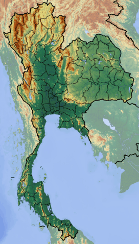
| Location | Chiang Mai, Thailand |
| Range | Shan Hills |
| Coordinates | 18°35′15″N 98°29′12″E / 18.58750°N 98.48667°ECoordinates: 18°35′15″N 98°29′12″E / 18.58750°N 98.48667°E |
| Geology | |
| Type | granite batholith |
| Climbing | |
| Easiest route | drive |
Doi Inthanon (Thai: ดอยอินทนนท์ (pronunciation)) is the highest mountain in Thailand. It is in Chom Thong District, Chiang Mai Province. This mountain is an ultra prominent peak, known in the past as Doi Luang (meaning "big mountain") or Doi Ang Ka, meaning "the crow's pond top". Near the mountain's base was a pond where many crows gathered. The name Doi Inthanon was given in honour of the king Inthawichayanon, one of the last kings of Chiang Mai, who was concerned about the forests in the north and tried to preserve them. He ordered that after his death his remains be interred at Doi Luang, which was then renamed in his honour.
Today, the summit of Doi Inthanon is a popular tourist destination for both foreign and Thai tourists, with a peak of 12,000+ visitors visiting the summit on New Year's Day. In addition to a range of tourist facilities on the summit, there is also a Royal Thai Air Force weather radar station at the summit.
Geography
Doi Inthanon is the highest peak of the Inthanon Range (Thai: ทิวเขาอินทนนท์) of the Thanon Thong Chai Range, a subrange of the Shan Hills in the Thai highlands stretching southwards from the Daen Lao Range. This range, the southwesternmost of the Shan Highland system, separates the Salween watershed from the Mekong watershed. Other high peaks of the Loi Lar Mountain Range are Doi Luang Chiang Dao (2,175 m), Doi Pui (1,685 m), and Doi Suthep (1,601 m).
In 1954, the forests around Doi Inthanon were conserved, creating Doi Inthanon National Park, as one of the original 14 national parks of Thailand. This park now covers 482.4 km² and spreads from the lowlands at 800 m elevation up to the peak at 2,565 m. The summit experiences average year-round temperatures in the low- to mid-teens (Celsius) and high humidity. It is not uncommon for the temperature to drop below zero during the winter months. Given the varied climatic and ecological areas regions, the park supports a range of animal species, including over 360 bird species.
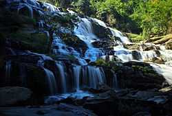
On the lower slope of Doi Inthanon, near the Karen hill tribe village, Ban Sop Had, are the Wachirathan waterfalls (Thai: น้ำตกวชิรธาร), where the Wachirathan (lit. "Diamond Creek") tumbles over a granite escarpment.18°32′30″N 98°35′57″E / 18.541790°N 98.599247°E
The two chedis
On the main road to the summit of Doi Inthanon stand two adjacent chedis, one called Naphamethinidon (นภเมทินีดล), meaning "by the strength of the land and air", and the other, Naphaphonphumisiri (นภพลภูมิสิริ), meaning "being the strength of the air and the grace of the land". These temples were built to honour the 60th birthday anniversary of King Bhumibol Adulyadej in 1987, and the 60th birthday anniversary of Queen Sirikit in 1992, respectively.
Geology
Geologically the mountain is a granite batholith in a north-south oriented mountain range. The second-highest peak of this range is Doi Hua Mot Luang at 2,340 m.
Gallery
-
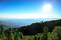
View west from Doi Inthanon
-
Mae Ya Waterfall
-
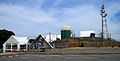
Doi Inthanon control and reporting center on the summit
-
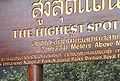
Sign marking the top of Doi Inthanon
-
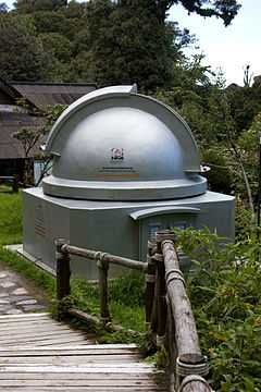
Thai National Observatory
See also
- List of mountains in Thailand
- List of Southeast Asian mountains
- List of Ultras of Southeast Asia
- Doi Inthanon rock frog
- Thai National Observatory
References
External links
| Wikimedia Commons has media related to Doi Inthanon. |
 Doi Inthanon travel guide from Wikivoyage
- thaibirding.com on Doi Inthanon
- www.DoiInthanon.net
- "Doi Inthanon, Thailand" on Peakbagger