Doab
| Doab دوآب / दोआब | |
|---|---|
| Natural region | |
|
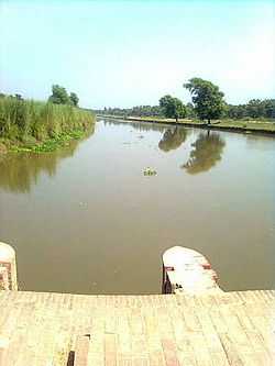
View of a canal in the lower Bari Doab of the Punjab Doabs | |
| Country | Pakistan and India |
Doab (Urdu: دوآب, Hindi: दोआब,[1] from Persian: دوآب dōāb, from dō, "two" + āb, "water" or "river") is a term used in India and Pakistan for the "tongue,"[2] or tract of land lying between two converging, or confluent, rivers. It is similar to an interfluve,[3] In the Oxford Hindi-English Dictionary, R. S. McGregor defines it as "a region lying between and reaching to the confluence of two rivers (esp. that between the Ganges and Jumna)."[1]
In India, "doab" is now largely a historical term applied to pre-1947 India, seldom used in contemporary Hindi or Indian English.
The Doab

The Doab, unqualified by the names of any rivers, designates the flat alluvial tract between the Ganges and Yamuna rivers extending from the Sivalik Hills to the two rivers' confluence at Allahabad. The region has an area of about 23,360 square miles (60,500 square km); it is approximately 500 miles (805 km) in length and 60 miles (97 km) in width.
The region of the Doab figures prominently in the history and myths of Vedic period. The British divided the Doab into three administrative districts or zones, viz., Upper Doab (Meerut), Middle Doab (Agra) and Lower Doab (Allahabad). These districts are now divided into several other districts as enumerated below.
The following districts/states form part of the Doab:
Upper Doab
Dehradun, Haridwar, Rishikesh, Muzaffarnagar, Saharanpur, Meerut, Ghaziabad, Gautam Buddh Nagar, Bulandshahr and Delhi.
Central or Middle Doab
Etah, Kasganj, Aligarh, Agra, Hathras, Firozabad, Farrukhabad, Mainpuri, Etawah, and Mathura. Mathura is in the trans-Yamuna region of Braj.
Lower Doab
Kanpur, Fatehpur, Kaushambi and Allahabad.
The Punjab Doabs
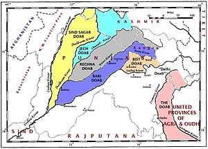
Each of the tracts of land lying between the confluent rivers of the Punjab region of Pakistan and India (the Indus basin) has a distinct name, said to have been coined by Raja Todar Mal, a minister of the Mughal emperor Akbar. The names (except for 'Sindh Sagar') are a combination of the first letters, in the Persian alphabet, of the names of the rivers that bound the Doab. For example, Jech = 'Je'(Jhelum) + 'Ch'(Chenab). The names are (from west to east):
- Sind Sagar Doab - lies between the Indus and Jhelum River rivers.
- Jech Doab (also Chaj) Doab - between the Jhelum and the Chenab River.
- Rechna Doab - between the Chenab and the Ravi River.
- Bari Doab or Majha - between the Ravi and the Beas River.
- Bist Doab (also Jullundur Doab or Doaba) - between the Beas and the Sutlej river.
In addition, the tract of land lying between the Sutlej and the Yamuna river is sometimes called the Delhi doab, although, strictly speaking, it is not a doab, since its two bounding rivers, the Yamuna and Sutlej, are not confluent.
Raichur
The Raichur Doab is the triangular region of Andhra Pradesh and Karnataka states which lies between the Krishna River and its tributary the Tungabhadra River, named for the town of Raichur.
Notes
- ↑ 1.0 1.1 McGregor 1993, p. 513.
- ↑ doab or duab, n., OED Online, Oxford University Press, September 2013, retrieved 11 September 2013
- ↑ Doab., Webster's Third New International Dictionary, Unabridged., 2013, retrieved 11 September 2013
References
- McGregor, Ronald Stuart (1993), The Oxford Hindi-English Dictionary, Oxford University Press, p. 513, ISBN 978-0-19-864339-5, retrieved 11 September 2013
| ||||||||||||||||||||||||||||||||||||||||
| ||||||||||||||