Dniprodzerzhynsk Hydroelectric Power Plant
| Dniprodzerzhynsk Dam | |
|---|---|
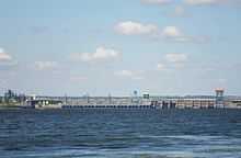 View power station and dam | |
 | |
| Official name | Dneprodzerzhinska HPS |
| Location | Dniprodzerzhynsk, Ukraine |
| Coordinates | 48°32′52.80″N 34°32′28.67″E / 48.5480000°N 34.5412972°ECoordinates: 48°32′52.80″N 34°32′28.67″E / 48.5480000°N 34.5412972°E |
| Purpose | Power, navigation |
| Status | Operational |
| Construction began | 1956 |
| Opening date | 1963 |
| Dam and spillways | |
| Type of dam | Earth-fill embankment with gravity sections |
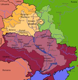
| Impounds | Dnieper River |
| Height | 15.5 m (51 ft) |
| Length | 7,490 m (24,570 ft) |
| Reservoir | |
| Creates | Dniprodzerzhynsk Reservoir |
| Total capacity | 2,450,000,000 m3 (1,986,247 acre·ft) |
| Surface area | 567 km2 (219 sq mi) |
| Power station | |
| Operator(s) | Ukrhydroenerho |
| Commission date | 1963-1964 |
| Turbines | 8 x 44 MW propeller |
| Installed capacity | 352 MW |
| Annual generation | 1.4 TWh |
The Dniprodzerzhynsk Hydroelectric Station is a run-of-river power plant on the Dnieper River in Dniprodzerzhynsk, Ukraine. The primary purpose of the dam is hydroelectric power generation and navigation. It is the fourth dam in the Dnieper cascade. The dam has an associated lock and a power station with an installed capacity of 352 MW. Construction on the dam began in 1956 and the last generator was commissioned in 1964.[1] It is operated by Ukrhydroenerho.[2]
References
- ↑ "Hydroelectric Power Plants in Ukraine". IndustCards. Retrieved 28 February 2014.
- ↑ "Dneprodzerzhinska HPS" (in Russian). UGE. Retrieved 28 February 2014.
| |||||||||||||||||||||||||||||