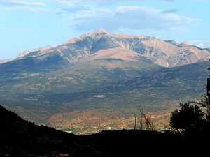
Djurdjura National Park
| Djurdjura National Park | |
|---|---|
|
IUCN category II (national park) | |
 | |
| Location | Kabylie, Algeria |
| Nearest city | Tizi Ouzou, Bouïra |
| Coordinates | 36°28′N 4°11′E / 36.467°N 4.183°ECoordinates: 36°28′N 4°11′E / 36.467°N 4.183°E |
| Area | 82.25 km² |
| Established | July 23, 1983 |
| Visitors | 500 000 |
The national park of Djurdjura (Arabic: الحديقة الوطنية جرجرة) is one of the national parks of Algeria. It is located in Kabylie and is named after the Djurdjura Range of the Tell Atlas.
Description
Nearby cities include Tizi Ouzou to the north and Bouïra to the south. The park is home to a very broken tectonics, as well as many forests, grottoes, gorges, and important fauna, including the endangered Barbary Macaque,[1] Macaca sylvanus, a primate whose prehistoric distribution in North Africa was much broader than today.[2]
Name
The name of the mountain chain comes from the Kabyle word Jjerjer which means "great cold" or "elevation", from the old compound word Jer n Jer "the mountain of the mountains".[3] The Roman Empire used to call it Iron mountain in Latin (Mons Ferratus), in reference to the soil of the region, as well as to the resistance of the Kabyles against the Roman annexation of Kabylie. The name Djurdjura is also used for the villages located in this mountain chain. Mmis n'Djerdjer means "children of the Djurdjura", which is a Kabyle word referring to mountain inhabitants, there is also a Kabyle female group called DjurDjura.
Gallery
References
- ↑ IUCN. 2008. Redlist: Macaca sylvanus
- ↑ C. Michael Hogan. 2008. Barbary Macaque: Macaca sylvanus, GlobalTwitcher.com, ed. Nicklas Stromberg
- ↑ Énigmes et joutes oratoires de Kabylie by Youcef Allioui, L'Harmattan, 2005 ISBN 2-7475-8065-2
External links
| Wikimedia Commons has media related to Djurdjura National Park. |
| ||||||


