Ditton Park
Ditton Park was part of the Manor of Ditton which was in what was formerly the south east corner of the English county of Buckinghamshire, before the county boundary reorganisations of 1974 & 1998 which moved it to the Slough Unitary Authority, which is in the ceremonial county of Berkshire.
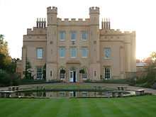
Ditton Park belonged to the crown in the reign of Queen Elizabeth I. It then belonged to Sir Ralph Winwood and passed to Ralph Montagu, 1st Duke of Montagu, through marriage. The present house which may have been first built around 1500 was badly damaged by fire in 1812. One of the features is the moat which surrounds the house and the immediate grounds. Park areas lie to the north and west of the moat.
Nearby, on the Great West Road, a public house known as the Montague [sic] Arms stands, now owned and operated as a Harvester restaurant. The pub dates back to the early 19th century
From the house (locally known as the Ditton Castle), a drive runs to the parish church of St. Mary the Virgin , Langley, via Conduit Way, Cedar Way, Green Drive and into the churchyard via Minster Way. This drive is evident on historical maps of the area.
In 1917 the property was taken over for the Admiralty Compass Observatory, which used the house and its immediate grounds until it was sold to Computer Associates (now CA Technologies) in the 1990s. It has now been restored and re-landscaped and functions as a conference centre.
In the late 1990s, local concern was raised regarding the issue of radioactive contamination arising from the World War II era burial of radium based, luminous paints . The Ministry of Defence successfully removed the contaminated material before the sale of the property to Computer Associates.
In 1920 West park started to be used for radio research, and this extended into the North park in 1924, and these activities eventually lead to the formation of the Radio Research Station which continued to operate on the site until about 1982 when the lands were sold to Calor Gas.
It was at the Radio Research Station in Ditton Park in 1935 that the idea for the development of the British radar defence system (Chain Home) was conceived in 1935.
Further reading
| Wikimedia Commons has media related to Ditton Park. |