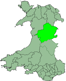
District of Montgomeryshire
Coordinates: 52°38′24″N 3°28′08″W / 52.640°N 3.469°W
| Montgomeryshire Welsh: Maldwyn | |
|---|---|
 | |
| Area | |
| - 1974 | 510,109 acres (2,064.34 km2)[1] |
| Population | |
| - 1973[1] | 43,580 |
| - 1992[2] | 53,700 |
| History | |
| - Created | 1974 |
| - Abolished | 1996 |
| - Succeeded by | Powys |
| Status | District |
| - HQ | Newtown |
 | |
Montgomeryshire District Council or Montgomeryshire (Welsh: Maldwyn) was, from 1974 to 1996, one of three districts of the county of Powys, Wales. The district had an identical area to the previous administrative county of Montgomeryshire.
The district was formed as Montgomery on 1 April 1974 as part of a general reorganisation of local government in England and Wales under the Local Government Act 1972. The new district replaced ten local authorities:
- The municipal boroughs of Llanfyllin, Llanidloes, Montgomery and Welshpool
- The urban districts of Machynlleth and Newtown and Llanllwchaiarn
- The rural districts of Forden, Llanfyllin, Machynlleth and Newtown and Llanidloes.[1][3]
In 1986 the name of the district was changed to Montgomeryshire by resolution of the council.
On 1 April 1996 the two-tier system of councils introduced in Wales in 1974 was replaced, and the country was divided into twenty-two counties and county boroughs by the Local Government (Wales) Act 1994. Accordingly the district was abolished, with its area passing to the county of Powys.[4]
References
- ↑ 1.0 1.1 1.2 Local government in England and Wales: A Guide to the New System. London: HMSO. 1974. p. 107. ISBN 0117508470.
- ↑ OPCS Key Population and Vital Statistics 1992
- ↑ Schedule 4: Local government areas in Wales, Local Government Act 1972 (c.70)
- ↑ "Schedule I: The New Principal Areas". Local Government (Wales) Act 1994 (c. 19). Office of Public Sector Information. 1994. Retrieved 2009-01-30.
| ||||||||||||||||||||||||||||||||||