Dippoldiswalde
| Dippoldiswalde | ||
|---|---|---|
| ||
 Dippoldiswalde | ||
Location of Dippoldiswalde within Sächsische Schweiz-Osterzgebirge district 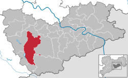 | ||
| Coordinates: 50°53′36″N 13°40′0″E / 50.89333°N 13.66667°ECoordinates: 50°53′36″N 13°40′0″E / 50.89333°N 13.66667°E | ||
| Country | Germany | |
| State | Saxony | |
| District | Sächsische Schweiz-Osterzgebirge | |
| Government | ||
| • Mayor | Ralf Kerndt (Unabhängige Bürger) | |
| Area | ||
| • Total | 104.13 km2 (40.20 sq mi) | |
| Population (2013-12-31)[1] | ||
| • Total | 14,508 | |
| • Density | 140/km2 (360/sq mi) | |
| Time zone | CET/CEST (UTC+1/+2) | |
| Postal codes | 01744 | |
| Dialling codes | 03504 | |
| Vehicle registration | PIR, DW, FTL, SEB | |
| Website | www.dippoldiswalde.de | |
Dippoldiswalde (Saxon: Dipps) is a town in the Free State of Saxony, Germany, administrative center of the Sächsische Schweiz-Osterzgebirge district. It is situated 23 km east of Freiberg, and 18 km south of Dresden.
The town is situated on the Weisseritz railway, a narrow gauge railway powered by steam locomotives.
References
- ↑ "Statistisches Landesamt des Freistaates Sachsen – Bevölkerung des Freistaates Sachsen jeweils am Monatsende ausgewählter Berichtsmonate nach Gemeinden" (PDF). Statistisches Landesamt des Freistaates Sachsen (in German). 6 September 2014.
| Wikimedia Commons has media related to Dippoldiswalde. |