Dinas Rhondda
| Dinas | |
 Dinas |
|
| OS grid reference | ST007917 |
|---|---|
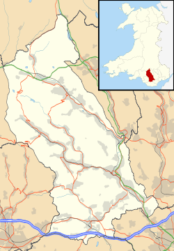
| Principal area | Rhondda Cynon Taf |
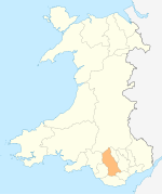
| Ceremonial county | Mid Glamorgan |
| Country | Wales |
| Sovereign state | United Kingdom |
| Post town | TONYPANDY / PORTH |
| Postcode district | CF40 / CF39 |
| Dialling code | 01443 |
| Police | South Wales |
| Fire | South Wales |
| Ambulance | Welsh |
| EU Parliament | Wales |
| UK Parliament | Rhondda |
| Welsh Assembly | Rhondda |
|
|
Coordinates: 51°37′10″N 3°25′51″W / 51.61948°N 3.43073°W
Dinas is a village near Tonypandy in the county borough of Rhondda Cynon Taf, Wales. Dinas is often referred to as Dinas Rhondda to avoid confusion with Dinas Powys in the Vale of Glamorgan. Other neighbouring settlements are Penygraig, Trealaw, Cymmer and Porth. The word dinas in Modern Welsh means "city", but here (as in Old and Middle Welsh more generally) it means "hill fort".
Dinas is the site of Dinas Lower (Dinas Isaf/Dinas Ishaf) Colliery, sunk by Walter Coffin in 1812 as the first deep coal mine in the Rhondda valley. This was later followed by the sinking of the Dinas Middle Colliery in 1832 along the southern banks of the river Rhondda Fawr, opposite Dinas Rhondda railway station. From here coal was carried by trams via Porth, Cymmer, and Trehafod to Pontypridd, where it was conveyed by canal to Cardiff. By 1893 production had ceased in both collieries.
In 1841 the 4-mile long Rhondda branch line of the Taff Vale Railway was opened between Pontypridd and Dinas, eventually to be extended as far as Treherbert by 1856. Dinas was also home to the first Methodist Chapel established in the Rhondda, the Ebenezer having been built around 1830.
External links
| ||||||||||||
