Diluvium


In the Geologic time scale used nowadays in Geology the term Diluvium has been replaced by Pleistocene.
Diluvium is a term in geology for superficial deposits formed by flood-like operations of water, and so contrasted with alluvium or alluvial deposits formed by slow and steady aqueous agencies. The term was formerly given to the boulder clay deposits, supposed to have been caused by the Noachian deluge.

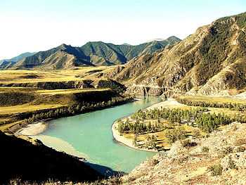
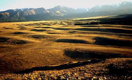
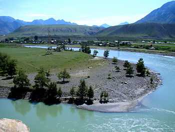
In the late 20th century Russian geologist Alexei Rudoy proposed the term "diluvium" for description of deposits created as a result of catastrophic outbursts of Pleistocene giant glacier-dammed lakes in intermontane basins of the Altai.[1] The largest of these lakes, Chuya and Kuray, had volumes of water in hundreds of cubic kilometers, and their discharge in peak hydrograph flow rate exceeded the maximum rates of the well-known Pleistocene Lake Missoula floods in North America. The term "diluvium" in the meaning of A. N. Rudoy has become accepted, and the process of diluvial morpholithogenesis can be found in modern textbooks.
Flood deposits of the Altai region
Nearly all intermountain depressions in southern Siberia and northern Mongolia hosted glacier-dammed lakes during the Pleistocene ice ages. Climatic changes and hydrostatic alterations of the ice dams were followed by repeated fillings and releases of the basin lakes. The lake outbursts had a cataclysmic character. In accordance with climatic conditions, the glaciers would protrude again into the main drainage valleys immediately after dam deformations and lake outbursts and would again dam the basins.
The greatest of the lakes (Lakes Chuya, Kuray, Uymon, Darkhat and others) achieved volumes up to hundreds of cubic kilometres, while the discharges of the outburst floods reached millions of cubic metres per second. These floods transformed the drainage valleys, repeatedly building new sediment deposits. The dating of the latter proves the occurrence of large-scale floods in the Chuya and the Katun River valleys in the interval between 23 and 7 thousand years ago. During that period there were at least five large-scale flooding events. Enormous water masses were drained simultaneously and repeatedly toward the south of West Siberia. The total water volume out of the Altai basins only used to reach 10 thousand cubic kilometres. With some periodicity, all of the basins of South Siberia were able to deliver northwards about 60 thousand cubic kilometres of flood waters.[2]
See also
References
- ↑ Lee, Keenan, 2004, The Altai Flood
- ↑ Rudoy A.N. Mountain Ice-Dammed Lakes of Southern Siberia and their Influence on the Development and Regime of the Runoff Systems of North Asia in the Late Pleistocene. Chapter 16. (P. 215—234.) — Palaeohydrology and Environmental Change / Eds: G. Benito, V.R. Baker, K.J. Gregory. — Chichester: John Wiley & Sons Ltd, 1998. 353 p.
- Chuya Flood Video
- Rudoy, A.N., Glacier-dammed lakes and geological work of glacial superfloods in the Late Pleistocene, Southern Siberia, Altai Mountains, Quaternary International, 2002, Vol. 87/1, pp. 119-140.
- Baker, V. R., G. Benito, A. N. Rudoy, Paleohydrology of late Pleistocene Superflooding, Altay Mountains, Siberia, Science, 1993, Vol. 259, pp. 348–352
- Huggett Richard J., Fundamentals of Geomorphology, N.Y.: Routledge, 2007
- Rudoy A.N., Ice-dammed lakes and glacial debris super-flows in the Altay and the Sayan Mountains in late Wurm: a review
- Рудой А. Н. Giant current ripples: A Review. 12. 2010.
- Рудой А. Н. Study diluvium: general provisions. Учение о дилювии (общие положения)
- Рудой А. Н., Земцов В. А. Новые результаты моделирования гидравлических характеристик дилювиальных потоков из позднечетвертичного Чуйско-Курайского ледниково-подпрудного озера.
- Diluvium Video
- Athabasca-video in large Scale
- Alexei Rudoy. Giant gravel bars - дилювиально-аккумулятивные валы ("высокие террасы").
- А. Н. Рудой. Study diluvium: general provisions. Общие положения учения о дилювии.
- Glacial Lakes and Glacial Lake Outburst Floods in Nepal. - International Centre for Integrated Mountain Development, Kathmandu, March 2011
| ||||||||||||||||||||||||||||||||||||||