Diedrichshagener Berg
| Diedrichshagener Berg | |
|---|---|
 Diedrichshagener Berg | |
| Elevation | 129.8 m above sea level (NHN) (426 ft) |
| Location | |
| Coordinates | 54°06′23″N 11°46′11″E / 54.10639°N 11.76972°ECoordinates: 54°06′23″N 11°46′11″E / 54.10639°N 11.76972°E |
| Geology | |
| Type |
Drift of the Pomeranian Stadium of the Weichselian glaciation Ice age terminal moraine |
| Age of rock | 15,600 to 13,700 years ago |
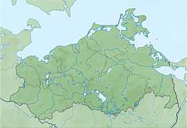
The Diedrichshagener Berg, at 129.8 metres, is the highest point on the forested ridge of Kühlung in the northeast German state of Mecklenburg-Vorpommern.
It is located in the district of Rostock only roughly southeast of the Bay of Mecklenburg, south of the Baltic Sea coast, and immediately south of Kühlungsborn and roughly west of Bad Doberan.
-
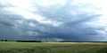
View looking towards Kröpelin
-
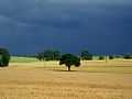
On the Diedrichshagener Berg