Dicky Beach, Queensland
| Dicky Beach Sunshine Coast, Queensland | |||||||||||||
|---|---|---|---|---|---|---|---|---|---|---|---|---|---|
|
Dicky Beach | |||||||||||||
| Coordinates | 26°46′59″S 153°07′59″E / 26.783°S 153.133°ECoordinates: 26°46′59″S 153°07′59″E / 26.783°S 153.133°E | ||||||||||||
| Population | 1,489 (2006 census)[1] | ||||||||||||
| • Density | 1,650/km2 (4,280/sq mi) | ||||||||||||
| Postcode(s) | 4551 | ||||||||||||
| Area | 0.9 km2 (0.3 sq mi) | ||||||||||||
| Location | 3 km (2 mi) NE of Caloundra | ||||||||||||
| LGA(s) | Sunshine Coast Region | ||||||||||||
| County | Canning | ||||||||||||
| Parish | Bribie | ||||||||||||
| State electorate(s) | Caloundra | ||||||||||||
| Federal Division(s) | Fisher | ||||||||||||
| |||||||||||||
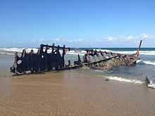
SS Dicky in December 2012
Dicky Beach is a suburb of the Sunshine Coast, Queensland, Australia, located within the Caloundra urban centre.
The area was named after the iron steamboat, the SS Dicky, which ran aground during heavy seas in 1893.[2] It was refloated, but again, heavy seas turned the ship about and back onto the sand where it remains to this day. Dicky Beach remains the only recreational beach in the world to be named after a shipwreck.[3]
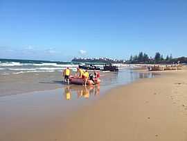
Dicky Beach is a patrolled beach, and is home to the Dicky Beach Surf Life Saving Club. It has been awarded numerous awards, including the 'DHL Queensland Surf Life Saving Club of the Year' in 2009. There is also a caravan park in the area.
References
- ↑ Australian Bureau of Statistics (25 October 2007). "Dicky Beach (Caloundra City) (State Suburb)". 2006 Census QuickStats. Retrieved 11 June 2011.
- ↑ Monumental Queensland: signposts on a cultural landscape by Lisanne Gibson & Joanna Besley
- ↑ National Library of Australia