Dhanusa District
| Dhanusha धनुषा | |
|---|---|
| District | |
 | |
| Country | Nepal |
| Region | Central (Madhyamanchal) |
| Zone | Janakpur |
| Headquarters | Janakpur |
| Area | |
| • Total | 1,180 km2 (460 sq mi) |
| Population (2011[1]) | |
| • Total | 654,777 |
| • Density | 550/km2 (1,400/sq mi) |
| Time zone | NPT (UTC+5:45) |
| Main language(s) |
Maithali (85%) Nepali (4.4%) |
| Website |
ddcdhanusha |
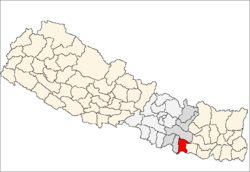
Dhanusha District, alternatively Dhanusha District, (Nepali: धनुषा जिल्ला ![]() Listen , a part of Janakpur Zone, is one of the seventy-five districts of Nepal.[2] The district, with Janakpur as its district headquarters, covers an area of 1,180 km² and has a population (2011) of 754,777.[1] It lies in the Central Development Region of Nepal. Also famous as a cultural center, the city attracts many Hindu pilgrims during festivals from both Nepal and India.
Listen , a part of Janakpur Zone, is one of the seventy-five districts of Nepal.[2] The district, with Janakpur as its district headquarters, covers an area of 1,180 km² and has a population (2011) of 754,777.[1] It lies in the Central Development Region of Nepal. Also famous as a cultural center, the city attracts many Hindu pilgrims during festivals from both Nepal and India.
During the elections in April 2008, the district was divided in seven constituencies. It is also the home district of the first president of Nepal, Dr. Ram Baran Yadav, who contested and won the elections from constituency 5. As a political center of the region, it has prominent leaders like Bimalendra Nidhi from the Nepali Congress, Anand yadav (Gangaram yadav) from the CPN-UML, and Matrika Yadav from the CPN-Maoist.
Janakpur, the headquarters of the district, was rocked by ethnic tension during and following uprisings in the Tarai, the southern plains of Nepal. Following the revolt, many people of Hill-origin fled the district and moved elsewhere, skewing the demography of the district. Dhalkebar, a town on the highway, has a majority of people of Hill-origin, while Janakpur has a majority of Madhesis, a Terai-origin community.
The most common language spoken in Dhanusa is Maithali.
Among the major places to visit in Dhanusa are its famous temples and lakes, mostly situated in Janakpur. These include the Janaki Temple, Dhanusadham where according to Hindu mythology a part of Shiva's bow that Lord Ram broke is said to have fallen, and the Vivah Mandap where it is believed Ram and Sita were married. A beautiful Mithila Women's Art Center is also a major tourist attraction.
Dhanusha district has an airport and the only Railway System of Nepal is also situated here which connects Janakpurdham with an Indian town, Jayanagar. It has several good hotels like Hotel Rama, Hotel Sita Palace including the starred hotel Hotel Welcome.[3] It also has the Janakpur Zonal Hospital and several private hospitals.
Geography and Climate
| Climate Zone[4] | Elevation Range | % of Area |
|---|---|---|
| Lower Tropical | below 300 meters (1,000 ft) | 92.5% |
| Upper Tropical | 300 to 1,000 meters 1,000 to 3,300 ft. |
7.5% |
Towns and villages

Andupatti, Aurahi, Bafai, Bagchaura, Baheda Bala, Bahuarba, Balabakhar, Balaha Kathal, Balaha Sadhara, Ballagoth, Baniniya, Baramajhiya, Basahiya, Basbitti, Bateswor, Bega Shivapur, Bengadawar, Bhathihan Bazar Bharatpur. Bhuchakrapur, Bhutahi Paterwa, Bindhi, Bisarbhora, Chakkar, Chhireshwarnath Municipality, Chora Koilpur, Debadiha, Deuri Parbaha, Devpura Rupetha, Dhabouli, Dhalkebar, Dhanauji, Dhanusadham Municipality, [[Dubarkoth Hathletwa ]], Duhabi, Ekarahi, Fulgama, Ghodghans, Giddha, Godar, Gopalpur, Goth Kohelpur, Hansapur Kathpula, Hariharpur, Hardiya, Harine, Hathipur Harbara, Inarwa, Itaharwa, Janakpur, Jhatiyahi, Jathai, Jhojhi Kataiya, [[Jamunibas,{i.e Bengadawar-3&4}]], Kachuri Thera, Kajara Ramaul, Kanakpatti, Khajuri Chanha, Khariyani, Kurtha, Labatoli, Lagmamdha Guthi, Lakhouri, Lakkad, Laxminibas, Laxmipur Bagewa, Lohana Bahbangama, Machijhitakaiya, Mahuwa, Mahuwa, Makhanaha, Manshingpatti, Mitheleswor Nikas, Mithileswor Mauwahi, Mujeliya, Mukhiyapatti, Mushargiya, Nagarain, Nakatajhijh, Nauwakhor Prashahi, Nunpatti, Pachaharwa, Papikleshwor, Patanuka, Paterwa, Paudeswor, Puspalpur, Raghunathpur, Ramaidaiya Bhawadi, Rampur Birta, Sabaila, Sakhuwa Mahendranagar, Sapahi, Satosar, Shantipur, Siddha, Singyahi Maidan, Sinurjoda, Sonigama, Suga Madhukarahi, Suganikash, Tarapatti Sirsiya, Thadi Jhijha, Thilla Yaduwa, Tulsi Chauda, Tulsiyahi Nikas, Tulsiyani Jabdi, Yadukush, Terha,Dumariya,
References
- ↑ 1.0 1.1 Household and population by districts, Central Bureau of Statistics (CBS) Nepal
- ↑ Districts of Nepal at statoids.com
- ↑ "Registered Star Hotels". Government of Nepal, Ministry of Tourism and Civil Aviation, Tourism Industry Division. Retrieved 2010-08-09.
- ↑ The Map of Potential Vegetation of Nepal - a forestry/agroecological/biodiversity classification system, . Forest & Landscape Development and Environment Series 2-2005 and CFC-TIS Document Series No.110., 2005, ISBN 87-7803-210-9, retrieved Nov 22, 2013
External links
- Dhanusa District map at Digital Himalaya (via Nepal Maps)
Coordinates: 26°43′43″N 85°55′31″E / 26.728598°N 85.925250°E