Deyrintar
| Deyrintar دير انطار | |
|---|---|
| City | |
|
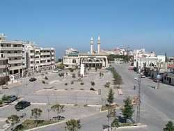
Main Square | |
 Deyrintar Location within Lebanon | |
| Coordinates: 33°13′07″N 35°22′33″E / 33.21861°N 35.37583°ECoordinates: 33°13′07″N 35°22′33″E / 33.21861°N 35.37583°E | |
| Country |
|
| Governorate | Nabatieh Governorate |
| District | Bint Jbeil District |
| Highest elevation | 670 m (2,200 ft) |
| Lowest elevation | 540 m (1,770 ft) |
| Time zone | EET (UTC+2) |
| • Summer (DST) | EEST (UTC+3) |
| Dialing code | +961 |
Deyrintar (Deir Intar, Arabic: دير انطار) is a small village in Southern Lebanon from Bint Jbeil District in Nabatieh Governorate.

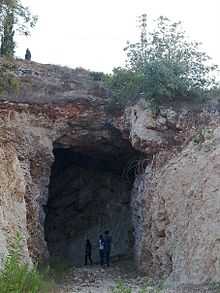
Cave of "2im Bzez"
Geography
It is about 110 kilometres (68 mi) south of Beirut and 25 kilometres (16 mi) east of Tyre, in the heart of what is known as "Jabal Amel".
Its main features include a cave, a main square, and 3 mosques.
Location
The village is surrounded several villages including: Tebnine, Sultaniyeh, beer alsalalssel, Majadel, Mahrona, Mazraait Mishrif, Haris, Kfardounine, and other southern villages steadfast
Families
- Hjej
- Nassreddin
- Sheayto
- Al-atrash
- Yassine
- Mehssin al-madi
- Abou raya
- Mjir
- Al-dayekh
- Kassir
- Al-attar
- Sheaytille
Municipal
Mayor: Mr. Kassem Hjej
Religious Monuments
There are 3 Mosques:
- Mosque Imam Mahdi (Almallule)
- Mosque Imam Hussein (Al-Barakah)
- Mosque Imam Ali (Al-shajara)
- Mosque ALl-Hamra
The Imam or khatib of Deyrintar are:
- The judge Sayyid Hussein Ahmad Touffaha (Son of Sayyid Ahmad Zaki Touffaha al-Hussayni)
- Sheikh Haitham Youssef Hjej
Civilian Facilities
- The municipal building
- Shiite shrine
- The public square
Monuments
The most prominent landmarks:
- Beaufort bees
- Ein zarka
- The cave
