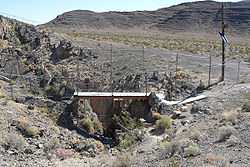
Devils Hole


Devils Hole is a geologic formation located within the Ash Meadows National Wildlife Refuge, in Nye County, Nevada Southwestern United States.
Description
Devils Hole is a geothermal aquifer-fed pool within a limestone cavern in the Amargosa Desert in the Amargosa Valley of Nevada, east over the Amargosa Range and Funeral Mountains from Death Valley. Its waters are a near constant salinity and temperature (92 °F or 33 °C).[1]
Devils Hole branches into deep caverns at least 300 feet (91 m) deep from an opening at the surface that is approximately 6 by 18 feet (1.8 by 5.5 m). According to geologists, the caves were formed over 500,000 years ago.[2] The pool has frequently experienced activity due to far away earthquakes,[1] which have been likened to extremely small scale tsunamis.
Devils Hole is the only natural habitat of the Devils Hole pupfish, which thrives despite the hot, oxygen-poor water. It is an IUCN Red List endangered species. The enclosing cave is occasionally used as a roost for barn owls, which tend to increase diatom growth via guano.
See also
References
- ↑ 1.0 1.1 Devils Hole. National Park Service http://www.nps.gov/deva/naturescience/devils-hole.htm. Retrieved 28 January 2014. Missing or empty
|title=(help) - ↑ Landwehr, J. M.; I. J. Winograd (2012-03-01). Devils Hole, Nevada - A Primer : U.S. Geological Survey Fact Sheet 2012-3021. U.S. Geological Survey. Retrieved 2013-01-17.
- Landwehr, J.M. and Winograd, I.J., 2012, Devils Hole, Nevada—A Primer: U.S. Geological Survey Fact Sheet 2012–3021, 6 p., available online at http://pubs.usgs.gov/fs/2012/3021.
External links
![]() Media related to Devils Hole at Wikimedia Commons
Media related to Devils Hole at Wikimedia Commons
- "Devils Hole". Geographic Names Information System. United States Geological Survey. Retrieved 2009-08-10.
- The Southwestern Naturalist: "Pupfish Populations"
Coordinates: 36°25′31″N 116°17′27″W / 36.4252338°N 116.2908733°W