Desert Hills, Maricopa County, Arizona
| Desert Hills, Arizona | |
|---|---|
| Unincorporated community | |
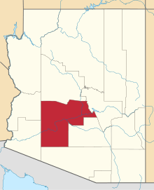
 Location in Maricopa County and the state of Arizona | |
| Country | United States |
| State | Arizona |
| County | Maricopa |
| Elevation | 1,863 ft (568 m) |
| Time zone | Arizona does not observe Daylight Savings (UTC-7) |
| ZIP codes | 85085, 85086 |
| Area code(s) | 623 |
Desert Hills is an unincorporated community in Maricopa County, Arizona, United States. Sitting on over 16 square miles (41 km2) of the 85086 Zip Code, And the (623) Area Code, forming the southern boundary of Anthem about 30 miles (48 km) north of downtown Phoenix. Located east of the I-17, Desert Hills is roughly bounded by 35th Avenue to the west, Desert Hills Drive to the north, 28th Street to the east, and the Carefree Highway to the south. Note a community known as Tramonto, falls within these boundaries but is considered part of Phoenix.
Desert Hills Estates
The once nameless rural area got its name from a .25 square mile community on the northwest corner of 7th Street and Joy Ranch Road, consisting of million dollar housing, the rest of the area is largely horse farms, no crop farms as the land is not fertile enough for farming.
The Geographic Names Information System database of the United States Geological Survey does not have a listing for Desert Hills itself, but includes listings for:
- U.S. Geological Survey Geographic Names Information System: Desert Hills Interchange
- U.S. Geological Survey Geographic Names Information System: Desert Hills Evangelical Free Church
- U.S. Geological Survey Geographic Names Information System: Desert Hills Fellowship Church
| |||||||||||||||||||||||||||||||||||||
Coordinates: 33°35′31″N 111°53′47″W / 33.5920407°N 111.8963565°W