Desaguadero River (Bolivia)
| Desaguadero | |
| River | |
| Countries | Peru, Bolivia |
|---|---|
| Region | Altiplano |
| Tributaries | |
| - left | Jach'a Jawira (Caquiaviri), Thujsa Jawira, Qala Jawira, Jach'a Jawira (Ingavi) |
| Cities | Desaguadero, San Andrés Municipality, Beni, Oruro |
| Source | Lake Titicaca |
| - location | Desaguadero, Peru & Bolivia |
| - elevation | 3,811 m (12,503 ft) |
| - coordinates | 16°33′49″S 69°02′11″W / 16.56361°S 69.03639°W |
| Mouth | Poopó Lake |
| - location | 50 kilometres (31 mi) S of Oruro, Bolivia |
| - elevation | 3,686 m (12,093 ft) |
| - coordinates | 18°26′31″S 67°04′22″W / 18.44194°S 67.07278°WCoordinates: 18°26′31″S 67°04′22″W / 18.44194°S 67.07278°W |
| Length | 320 km (199 mi) |
| Basin | 90,000 km2 (34,749 sq mi) approx. |
| Discharge | for Ulloma |
| - average | 78 m3/s (2,755 cu ft/s) |
| - max | 282 m3/s (9,959 cu ft/s) |
| - min | 28 m3/s (989 cu ft/s) |
The Desaguadero River in Peru and Bolivia is the river that drains Lake Titicaca. It exits the lake at the southern part of the river basin, it flows south and drains approximately five percent of the lake's flood waters into Lake Uru Uru and Lake Poopó.[1] It is navigable only by small craft and supports indigenous communities such as the Uru Muratus.
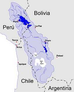
Sketch map of the area showing Desaguadero River
Notes
- ↑ "Desaguadero River (river, Bolivia)". Encyclopædia Britannica. Retrieved 2007-07-12.
See also
External links
| Wikimedia Commons has media related to Desaguadero River (Bolivia). |