Derchigny
| Derchigny | ||
|---|---|---|
| ||
 Derchigny | ||
|
Location within Upper Normandy region  Derchigny | ||
| Coordinates: 49°56′19″N 1°11′19″E / 49.9386°N 1.1886°ECoordinates: 49°56′19″N 1°11′19″E / 49.9386°N 1.1886°E | ||
| Country | France | |
| Region | Upper Normandy | |
| Department | Seine-Maritime | |
| Arrondissement | Dieppe | |
| Canton | Dieppe-Est | |
| Intercommunality | Communauté de communes du Petit Caux | |
| Government | ||
| • Mayor (2014-2020) | Daniel Maréchal | |
| Area1 | 4.75 km2 (1.83 sq mi) | |
| Population (2011)2 | 569 | |
| • Density | 120/km2 (310/sq mi) | |
| INSEE/Postal code | 76215 / 76370 | |
| Elevation |
40–116 m (131–381 ft) (avg. 100 m or 330 ft) | |
|
1 French Land Register data, which excludes lakes, ponds, glaciers > 1 km² (0.386 sq mi or 247 acres) and river estuaries. 2 Population without double counting: residents of multiple communes (e.g., students and military personnel) only counted once. | ||
Derchigny is a commune in the Seine-Maritime department in the Haute-Normandie region in north-western France. The local name is Derchigny-Graincourt as the commune is the reunion of two ancient communes, Derchigny and Graincourt.
Geography
A farming village situated in the Pays de Caux, some 5 miles (8.0 km) east of Dieppe, at the junction of the D 54 and the D 925 roads.
Heraldry
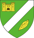 |
The arms of Derchigny are blazoned : Vert, a bend sinister argent between a castle and in base a coffee leaf bendwise sinister. |
Population
| Historical population | ||
|---|---|---|
| Year | Pop. | ±% |
| 1793 | 83 | — |
| 1800 | 85 | +2.4% |
| 1806 | 88 | +3.5% |
| 1821 | 95 | +8.0% |
| 1831 | 459 | +383.2% |
| 1836 | 446 | −2.8% |
| 1841 | 434 | −2.7% |
| 1846 | 407 | −6.2% |
| 1851 | 418 | +2.7% |
| 1856 | 413 | −1.2% |
| 1861 | 389 | −5.8% |
| 1866 | 412 | +5.9% |
| 1872 | 392 | −4.9% |
| 1876 | 380 | −3.1% |
| 1881 | 392 | +3.2% |
| 1886 | 397 | +1.3% |
| 1891 | 414 | +4.3% |
| 1896 | 391 | −5.6% |
| 1901 | 360 | −7.9% |
| 1906 | 376 | +4.4% |
| 1911 | 377 | +0.3% |
| 1921 | 369 | −2.1% |
| 1926 | 319 | −13.6% |
| 1931 | 346 | +8.5% |
| 1936 | 359 | +3.8% |
| 1946 | 392 | +9.2% |
| 1954 | 354 | −9.7% |
| 1962 | 282 | −20.3% |
| 1968 | 291 | +3.2% |
| 1975 | 314 | +7.9% |
| 1982 | 379 | +20.7% |
| 1990 | 384 | +1.3% |
| 1999 | 416 | +8.3% |
| 2004 | 476 | +14.4% |
| 2006 | 497 | +4.4% |
| 2009 | 559 | +12.5% |
| 2011 | 569 | +1.8% |
Places of interest
- The church of St.Martin, dating from the eighteenth century.
- The church of St.Valery, dating from the eleventh century.
- The eighteenth-century château de Wargemont (made famous by the owners, the Berard family, being patrons of Auguste Renoir).
- The château de Derchigny, dating from the eighteenth century.
See also
- Communes of the Seine-Maritime department
- Seine-Maritime
- Normandy
References
External links
| Wikimedia Commons has media related to Derchigny. |
- Derchigny on the Quid website (French)