Dennis F. Cantrell Field
| Dennis F. Cantrell Field | |||||||||||||||
|---|---|---|---|---|---|---|---|---|---|---|---|---|---|---|---|
 | |||||||||||||||
| IATA: none – ICAO: KCWS – FAA LID: CWS | |||||||||||||||
| Summary | |||||||||||||||
| Airport type | Public | ||||||||||||||
| Owner | City of Conway | ||||||||||||||
| Serves | Conway, Arkansas | ||||||||||||||
| Elevation AMSL | 316 ft / 96 m | ||||||||||||||
| Coordinates | 35°04′51″N 092°25′30″W / 35.08083°N 92.42500°WCoordinates: 35°04′51″N 092°25′30″W / 35.08083°N 92.42500°W | ||||||||||||||
| Map | |||||||||||||||
 CWS Location of airport in Arkansas | |||||||||||||||
| Runways | |||||||||||||||
| |||||||||||||||
| Statistics (2010) | |||||||||||||||
| |||||||||||||||
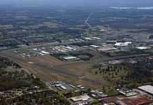
Dennis F. Cantrell Field (ICAO: KCWS, FAA LID: CWS, formerly M03) is a public use airport located one nautical mile (2 km) southeast of the central business district of Conway, in Faulkner County, Arkansas, United States. It is owned by the City of Conway.[1]
This airport is included in the FAA's National Plan of Integrated Airport Systems for 2011–2015, which categorized it as a general aviation airport.[2]
Although most U.S. airports use the same three-letter location identifier for the FAA and IATA, this airport is assigned CWS by the FAA but has no designation from the IATA[3] (which assigned CWS to Center Island, Washington).[4]
Facilities and aircraft
Dennis F. Cantrell Field covers an area of 198 acres (80 ha) at an elevation of 316 feet (96 m) above mean sea level. It has two asphalt paved runways: 8/26 is 4,875 by 100 feet (1,486 x 30 m) and 18/36 is 3,278 by 60 feet (999 x 18 m).[1]
For the 12-month period ending January 31, 2010, the airport had 16,000 aircraft operations, an average of 43 per day: 94% general aviation, 3% air taxi, and 3% military. At that time there were 41 aircraft based at this airport: 73% single-engine, 22% multi-engine, 2% jet, and 2% helicopter.[1]
References
- ↑ 1.0 1.1 1.2 1.3 FAA Airport Master Record for CWS (Form 5010 PDF). Federal Aviation Administration. Effective 25 August 2011.
- ↑ "2011–2015 NPIAS Report, Appendix A (PDF, 2.03 MB)" (PDF). 2011–2015 National Plan of Integrated Airport Systems. Federal Aviation Administration. 4 October 2010.
- ↑ "Conway, Arkansas (FAA: CWS, ICAO: KCWS)". Great Circle Mapper. Retrieved 19 October 2011.
- ↑ "Center Island Airport, Washington (IATA: CWS, FAA: 78WA)". Aviation Safety Network. Retrieved 19 October 2011.
External links
- Aerial image as of 5 April 2000 from USGS The National Map
- FAA Terminal Procedures for CWS, effective April 30, 2015
- Resources for this airport:
- FAA airport information for CWS
- AirNav airport information for CWS
- FlightAware airport information and live flight tracker
- SkyVector aeronautical chart for CWS