Dennis, Massachusetts
| Dennis, Massachusetts | ||
|---|---|---|
| Town | ||
| ||
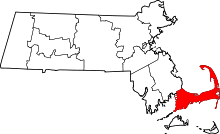
 Location in Barnstable County and the state of Massachusetts. | ||
| Coordinates: 41°44′07″N 70°11′40″W / 41.73528°N 70.19444°WCoordinates: 41°44′07″N 70°11′40″W / 41.73528°N 70.19444°W | ||
| Country | United States | |
| State | Massachusetts | |
| County | Barnstable | |
| Settled | 1639 | |
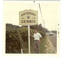
| Incorporated | 1793 | |
| Government | ||
| • Type | Open town meeting | |
| • Town Administrator | Richard White | |
| Area | ||
| • Total | 22.3 sq mi (57.7 km2) | |
| • Land | 20.5 sq mi (53.1 km2) | |
| • Water | 1.7 sq mi (4.5 km2) | |
| Elevation | 24 ft (7 m) | |
| Population (2010) | ||
| • Total | 14,207 | |
| • Density | 693/sq mi (267.4/km2) | |
| Time zone | Eastern (UTC-5) | |
| • Summer (DST) | Eastern (UTC-4) | |
| ZIP code | 02660 | |
| Area code(s) | 508 / 774 | |
| FIPS code | 25-16775 | |
| GNIS feature ID | 0618252 | |
| Website |
www | |

Dennis /ˈdɛnɪs/ is a town in Barnstable County, Massachusetts, United States, located near the center of Cape Cod. The population was 14,207 at the 2010 census.[1]
The town encompasses five distinct villages, each of which has its own post office. These constituent villages are Dennis (including North Dennis), Dennis Port, East Dennis, South Dennis, and West Dennis.[2]
History
Dennis was first settled in 1639, by John Crowe (later Crowell), Antony Thacher and Thomas Howes, as part of the town of Yarmouth. The town officially separated and incorporated in 1793. It was named after resident minister, Rev. Josiah Dennis.[3] There was not enough land for farming, so seafaring became the town's major industry in its early history, centered around the Shiverick Shipyard.
Currently, Dennis is a popular seaside resort town, notable for its stately colonial mansions along the northern Cape Cod Bay coastline, and its picturesque, warm-water beaches along the southern Nantucket Sound.[4]
The Cape Playhouse, in northern Dennis, is one of the oldest summer theatres in the United States (it is not clear which theatre is the oldest, as many make this claim), and among the best known. The actress Bette Davis was "discovered" while working there as an usher. Other famous Dennis residents include the author Mary Higgins Clark and actress Amy Jo Johnson, who grew up in Dennis.
Geography

The town of Dennis spans the width of Cape Cod, with Cape Cod Bay to the north, Brewster to the northeast, Harwich to the southeast, Nantucket Sound to the south, and Yarmouth to the west. The town is about 10 miles (16 km) east of Barnstable, 24 miles (39 km) east of the Sagamore Bridge, and 78 miles (126 km) southeast of Boston. The Town of Dennis comprises the villages of Dennis Port, Dennis Village (including North Dennis), East Dennis, South Dennis and West Dennis.
According to the United States Census Bureau, the town has a total area of 22.3 square miles (57.7 km2), of which 20.5 square miles (53.1 km2) is land and 1.7 square miles (4.5 km2), or 7.88%, is water.[1]
The town lies on the eastern banks of the Bass River, which nearly divides the cape in half. There are several small ponds and lakes in town, as well as Sesuit Harbor to the north and West Dennis Harbor to the south.
The area of Scargo Lake and Scargo Hill in Dennis are associated with ancient Native American folklore. The legend of the lake's creation was the inspiration for a children's book and an American folklore tale, the Legend of Scargo. When viewed from Scargo Tower atop the hill, Scargo Lake appears to be in the shape of a fish.
The north and south shores of the town have many beaches, as well as the Dennis Yacht Club in the north and West Dennis Yacht Club in the south.
While West Dennis is indeed west of Dennisport, it is south of South Dennis. East Dennis is north of South Dennis, and Dennis is on the western shore, to the west of East Dennis.
Demographics
| Historical population | ||
|---|---|---|
| Year | Pop. | ±% |
| 1850 | 3,257 | — |
| 1860 | 3,662 | +12.4% |
| 1870 | 3,269 | −10.7% |
| 1880 | 3,288 | +0.6% |
| 1890 | 2,899 | −11.8% |
| 1900 | 2,333 | −19.5% |
| 1910 | 1,919 | −17.7% |
| 1920 | 1,536 | −20.0% |
| 1930 | 1,829 | +19.1% |
| 1940 | 2,015 | +10.2% |
| 1950 | 2,499 | +24.0% |
| 1960 | 3,727 | +49.1% |
| 1970 | 6,454 | +73.2% |
| 1980 | 12,360 | +91.5% |
| 1990 | 13,864 | +12.2% |
| 2000 | 15,973 | +15.2% |
| 2010 | 14,207 | −11.1% |
| * = population estimate. Source: United States Census records and Population Estimates Program data.[5][6][7][8][9][10][11][12][13][14] | ||
As of the census[15] of 2000, there were 15,973 people, 7,504 households, and 4,577 families residing in the town. The census measures the year-round population; in the summer the population is estimated to be 63,000.[2] The census population density was 775.6 inhabitants per square mile (299.5/km2). There were 14,105 housing units at an average density of 684.9 per square mile (264.4/km2). The racial makeup of the town was 94.99% White, 1.93% Black or African American, 0.37% Native American, 0.37% Asian, 0.88% from other races, and 1.46% from two or more races. Hispanic or Latino of any race were 1.65% of the population.
There were 7,504 households out of which 18.8% had children under the age of 18 living with them, 49.0% were married couples living together, 9.2% had a female householder with no husband present, and 39.0% were non-families. 33.3% of all households were made up of individuals and 17.7% had someone living alone who was 65 years of age or older. The average household size was 2.11 and the average family size was 2.65.
In the town the population was spread out with 16.9% under the age of 18, 4.6% from 18 to 24, 22.2% from 25 to 44, 27.8% from 45 to 64, and 28.4% who were 65 years of age or older. The median age was 49 years. For every 100 females there were 85.6 males. For every 100 females age 18 and over, there were 82.7 males.
The median income for a household in the town was $41,598, and the median income for a family was $50,478. Males had a median income of $40,528 versus $29,153 for females. The per capita income for the town was $25,428. About 5.4% of families and 7.0% of the population were below the poverty line, including 10.4% of those under age 18 and 4.8% of those age 65 or over.
Beaches
All the public beaches in Dennis are owned by the town. The Northside beaches are located on Cape Cod Bay, while the Southside beaches are located on Nantucket Sound. Some of them have different names for different entrances. On the Northside, Corporation Beach and Howes Street Beach are on the same strip of public beach. The same goes for Mayflower Beach and Bayview* Beach, and Cold Storage* Beach and Sea Street Beach. Chapin Beach and Harborview* Beach are not paired with any other. On the Northside, the town also owns two beaches on Scargo Lake: Scargo Beach and Princess Beach.
The Southside beaches are Glendon Beach, Haigis Beach, Inman Road Beach, Maycroft Beach, Metcalfe Memorial Beach, West Dennis Beach, South Village Beach, and Sea Street Beach.
All of the public beaches in Dennis are free to walk on. However, every beach (except those with a *) charges a non-resident parking fee of $20 per day or $75 per week.[16] Residents (Dennis taxpayers) can buy beach parking stickers with proof of residency for $30 for the season. At resident-only beaches (marked with a *), non-residents may not park at all. (Of course in the winter, nobody checks for beach stickers)
Mayflower Beach[17] faces Cape Cod Bay and is named after the Pilgrims' ship, the Mayflower.[17]

Transportation
Dennis is crossed from east to west by Cape Cod's three main routes, U.S. Route 6, Massachusetts Route 6A and Massachusetts Route 28. Massachusetts Route 134 crosses the town south to north from Route 28 to Route 6A. (It is debatable that Route 134 is a Massachusetts state highway; it was technically the "East-West Dennis Road (Route 134)... an urban principal arterial owned by the Town" according to a Massachusetts Department of Transportation study by Howard/Stein-Hudson Associates of Boston written in July 2010. Whether it was later acquired by the state is not known. Technically a Massachusetts state highway has to cross town lines and the East-West Dennis Road does not. In addition it is called the East West Dennis Road because it "connects" East Dennis to West Dennis, not because it runs from east to west according to the compass.) East of the Route 134 exit, Route 6 (also known as the Mid-Cape Highway) downgrades from a four-lane divided highway to a two-lane limited access highway, divided only by markers.
The Cape's Bay Colony Rail service officially ends in the town. (Although the right off way for this line probably still exists, there is no longer a bridge over Bass River and no trains enter the town of Dennis.) The ending point is the starting point of the Cape Cod Rail Trail, a bicycle trail which runs "down" the Cape to Wellfleet along the former right-of-way of the railway. There are also several other bicycle trails in town. The nearest regional air service is at the Barnstable Municipal Airport, and the nearest national and international air service is at Logan International Airport in Boston.
Government
The town of Dennis is governed by an open town meeting form of government, and is led by a board of selectmen, which delegates day-to-day operations to a town administrator. The town has a police department, and the fire department headquartered near the intersection of Routes 28 and 134 with a branch station off of Route 6A. There are post offices in each of the five villages, as are the town's libraries. The central library is located in Dennis Port, and all are a part of the Cape Libraries Automated Materials Sharing library network. The town operates its own landfill, located southeast of the junction of Routes 6 and 134.[18]
Dennis is represented in the Massachusetts House of Representatives in the First Barnstable District. The town is represented in the Massachusetts Senate as a part of the Cape and Islands District, which includes all of Cape Cod (except the towns of Bourne, Falmouth, and Sandwich), and the islands of Martha's Vineyard and Nantucket.[19] The town is patrolled by the Second (Yarmouth) Barracks of Troop D of the Massachusetts State Police.[20]
Dennis in the Massachusetts 10th congressional district, and represented by William Keating. The state's senior (Class II) member of the United States Senate, elected in 2012, is Elizabeth Warren. The junior (Class I) senator, elected in 2013, is Ed Markey.
Education
Dennis shares its school system with Yarmouth to form the Dennis-Yarmouth Regional School District. The town itself operates the Ezra H. Baker School, which serves students from pre-kindergarten through third grade. The Nathaniel H. Wixon Middle School, which serves grades 4 and 5 from Dennis and Yarmouth and Mattacheese Middle school serves grades 6 and 7 from Dennis and Yarmouth. High school students attend Dennis-Yarmouth Regional High School in Yarmouth. Students are not officially contracted to any vocational high schools; private schools can be found in each of the neighboring towns.
Notable residents
- Edward Gelsthorpe (1923–2009), marketing executive called "Cranapple Ed" for his best-known product launch.[21]
- Mary Higgins Clark, author
- Amy Jo Johnson, actress
- Gertrude Lawrence, actress
- Mike Sherman, former coach of the Green Bay Packers and current coach of the Texas A&M Aggies
- Richard Valle, founder of Valle's Steak House restaurant chain
References
- ↑ 1.0 1.1 "Geographic Identifiers: 2010 Demographic Profile Data (G001): Dennis town, Barnstable County, Massachusetts". U.S. Census Bureau, American Factfinder. Retrieved December 4, 2013.
- ↑ 2.0 2.1 Dennis Police Department website, accessed December 22, 2010
- ↑ Gannett, Henry (1905). The Origin of Certain Place Names in the United States. Govt. Print. Off. p. 104.
- ↑ Cape Cod, Martha's Vineyard and Nantucket Street Atlas. South Easton, MA: Arrow Maps Inc., 2004, p. 42.
- ↑ "TOTAL POPULATION (P1), 2010 Census Summary File 1". American FactFinder, All County Subdivisions within Massachusetts. United States Census Bureau. 2010.
- ↑ "Massachusetts by Place and County Subdivision - GCT-T1. Population Estimates". United States Census Bureau. Retrieved July 12, 2011.
- ↑ "1990 Census of Population, General Population Characteristics: Massachusetts" (PDF). US Census Bureau. December 1990. Table 76: General Characteristics of Persons, Households, and Families: 1990. 1990 CP-1-23. Retrieved July 12, 2011.
- ↑ "1980 Census of the Population, Number of Inhabitants: Massachusetts" (PDF). US Census Bureau. December 1981. Table 4. Populations of County Subdivisions: 1960 to 1980. PC80-1-A23. Retrieved July 12, 2011.
- ↑ "1950 Census of Population" (PDF). 1: Number of Inhabitants. Bureau of the Census. 1952. Section 6, Pages 21-10 and 21-11, Massachusetts Table 6. Population of Counties by Minor Civil Divisions: 1930 to 1950. Retrieved July 12, 2011.
- ↑ "1920 Census of Population" (PDF). Bureau of the Census. Number of Inhabitants, by Counties and Minor Civil Divisions. Pages 21-5 through 21-7. Massachusetts Table 2. Population of Counties by Minor Civil Divisions: 1920, 1910, and 1920. Retrieved July 12, 2011.
- ↑ "1890 Census of the Population" (PDF). Department of the Interior, Census Office. Pages 179 through 182. Massachusetts Table 5. Population of States and Territories by Minor Civil Divisions: 1880 and 1890. Retrieved July 12, 2011.
- ↑ "1870 Census of the Population" (PDF). Department of the Interior, Census Office. 1872. Pages 217 through 220. Table IX. Population of Minor Civil Divisions, &c. Massachusetts. Retrieved July 12, 2011.
- ↑ "1860 Census" (PDF). Department of the Interior, Census Office. 1864. Pages 220 through 226. State of Massachusetts Table No. 3. Populations of Cities, Towns, &c. Retrieved July 12, 2011.
- ↑ "1850 Census" (PDF). Department of the Interior, Census Office. 1854. Pages 338 through 393. Populations of Cities, Towns, &c. Retrieved July 12, 2011.
- ↑ "American FactFinder". United States Census Bureau. Retrieved 2008-01-31.
- ↑ "Town of Dennis Beaches". Retrieved August 3, 2010.
- ↑ 17.0 17.1 "MoreBeach: Mayflower Beach". www.morebeach.com.
- ↑ "Recycling Home". Archived from the original on July 11, 2007. Retrieved May 28, 2007.
- ↑ Index of Legislative Representation by City and Town, from Mass.gov
- ↑ Station D-2, SP Yarmouth
- ↑ Grimes, William. "Edward Gelsthorpe, Master Marketer, Dies at 88", The New York Times, September 27, 2009. Accessed September 29, 2009.
External links
| Wikimedia Commons has media related to Dennis, Massachusetts. |
- Town of Dennis official website
- Dennis Chamber of Commerce
- History of Barnstable County, Massachusetts (Dennis chapter)
- Cape Cod Rail Trail
- Dennis Public Library
- Dennis Memorial Library
 Dennis travel guide from Wikivoyage
| ||||||||||||||||||||||||||