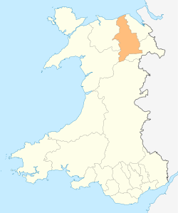
Denbighshire
 | |
| Geography | |
| Area - Total - % Water |
Ranked 8th 844 km² ? % |
|---|---|
| Admin HQ | Ruthin |
| ISO 3166-2 | GB-DEN |
| ONS code | 00NG |
| Demographics | |
| Population: - Total (2011) - Density |
Ranked 16th 93,700 Ranked 14th 115 / km² |
| Ethnicity | 99.3% White. |
| Welsh language - Any skills |
Ranked 6th 36.0% |
| Politics | |
 Denbighshire County Council http://www.denbighshire.gov.uk/ | |
| Control | TBA (council NOC) |
| MPs | |
| AMs |
|
| MEPs | Wales |
Denbighshire (Welsh: Sir Ddinbych) is a county in north-east Wales. It is named after the historic county of Denbighshire, but has substantially different borders. Denbighshire has the distinction of being the oldest inhabited part of Wales. Pontnewydd (Bontnewydd-Llanelwy) Palaeolithic site has remains of Neanderthals from 225,000 years ago. There are several castles in the region: Denbigh Castle, Rhuddlan Castle, Ruthin Castle, Castell Dinas Bran and Bodelwyddan Castle. One of Britain's smallest cathedrals is at St Asaph, itself one of the smallest cities.
Formation
The present principal area was formed on 1 April 1996, under the Local Government (Wales) Act 1994, from various parts of the county of Clwyd. It included the district of Rhuddlan (which was formed in 1974 entirely from Flintshire), the communities of Trefnant and Cefn Meiriadog from the district of Colwyn (which was entirely Denbighshire) and most of the Glyndŵr district. The part of the Glyndŵr district included the entirety of the former Edeyrnion Rural District, which was part of the administrative county of Merionethshire prior to 1974 – which covered the parishes of Betws Gwerfil Goch, Corwen, Gwyddelwern, Llangar, Llandrillo yn Edeirnion and Llansanffraid.
Other principal areas containing part of historic Denbighshire are Conwy, which picked up the remainder of the 1974–1996 Colwyn, and also the Denbighshire parts of the 1974–1996 Aberconwy, and Wrexham, which corresponds to the pre-1974 borough of Wrexham along with most of the Wrexham Rural District and also several parishes from Glyndŵr.
The post-1996 Powys includes the historic Denbighshire parishes of Llanrhaeadr-ym-Mochnant, Llansilin and Llangedwyn, which had formed part of Glyndŵr district.
Geography
- See List of places in Denbighshire for a list of towns and villages.
The area is mostly hilly moorland, with the Clwydian Range in the east, the Hiraethog Moors (Mynydd Hiraethog) in the west and the Berwyn range adjacent to the southern boundary. The broad, fertile Vale of Clwyd runs south to north in the centre, and there is a narrow coastal plain in the north. Average temperatures are 2°C in January and 19°C in July.
Population
Denbighshire's total population at the United Kingdom Census 2001 was 93,065, with the largest towns on the coast at Rhyl (pop. c.25,000) and Prestatyn (pop. c.18,000). The inland towns are much smaller, Denbigh having a population of 8,500, Ruthin 5,000, and Llangollen 3,300. Welsh is spoken by 28% of the population, mainly in the upland area and the Vale of Clwyd. The county has seen a substantial influx from across the border to the extent that 38% of the population were born in England.
Economy
Since the 20th century demise of the coal and steel industries in the Wrexham area, there are no heavy industrial sites in the county although most of the towns have small industrial parks or estates for light industry, the economy of the area being based on agriculture and tourism. A large proportion of the working population is employed in the service sector. The uplands support the rearing of sheep and beef cattle, while in the Vale of Clwyd dairy farming and the growing of wheat and barley crops predominates.
On 19 November 2004 Denbighshire was granted Fairtrade County status.
Denbighshire is home to Wales' largest Medieval Festival, staged annually over the second weekend in August at Bodelwyddan Castle. It attracts re-enactment groups from all over the country.
Notable people who lived in Denbighshire
- Neil Aspinall, music industry executive
- Harold Bird-Wilson, WWII RAF flying ace
- Arthur Cheetham, first film-maker based in Wales, worked in Rhyl
- Danny Coyne, Middlesbrough F.C. goalkeeper was born in Prestatyn.
- Peggy Cummins, actress
- Ruth Ellis, last woman to be hanged in Britain in 1955.
- Jonathan Elphick, noted ornithologist
- Ched Evans, professional footballer.
- Lee Evans, comedian, actor
- Philip Jones Griffiths, Vietnam War photographer and President of Magnum
- Albert Gubay, businessman (Kwik Save)
- Ted Hankey, darts player
- Adrian Henri, poet/painter.
- Barry Hilton, South African comedian.
- Lancelot Hogben, biologist
- Sir John T. Houghton, leading scientist, former Chief Executive of the Met Office and former co-chair of the Intergovernmental Panel on Climate Change
- Nerys Hughes, television actress
- Emyr Humphreys, author
- Sir Robert Jones, Bt, KBE, CB (1857–1933), orthopaedic surgeon.
- Eifion Lewis-Roberts, professional rugby player
- Peter Moore, serial killer.
- Emma Parker, early 19th century novelist
- John Prescott, politician
- Mike Peters, musician (The Alarm).
- Lisa Scott-Lee, Member of pop group Steps.
- Sir Henry Morton Stanley, explorer
- Steve Strange, pop singer
- Sara Sugarman, film director
- Carol Vorderman, actress, television personality
- Karl Wallinger musician (World Party)
See also
- Denbighshire (historic)
- List of Lord Lieutenants of Denbighshire
- List of Custodes Rotulorum of Denbighshire
- List of High Sheriffs of Denbighshire
- Denbighshire (UK Parliament constituency)
- List of places in Denbighshire
- List of schools in Denbighshire
External links
- Denbighshire at DMOZ
- Denbighshire landscape
Coordinates: 53°05′12″N 3°21′16″W / 53.08667°N 3.35444°W
| ||||||