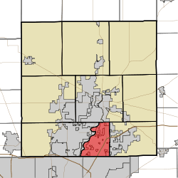
Delaware Township, Hamilton County, Indiana
| Delaware Township | |
|---|---|
| Township | |
 Location in Hamilton County | |
| Coordinates: 39°57′25″N 86°01′37″W / 39.95694°N 86.02694°WCoordinates: 39°57′25″N 86°01′37″W / 39.95694°N 86.02694°W | |
| Country | United States |
| State | Indiana |
| County | Hamilton |
| Government | |
| • Type | Indiana township |
| Area | |
| • Total | 15.66 sq mi (40.6 km2) |
| • Land | 15.22 sq mi (39.4 km2) |
| • Water | 0.44 sq mi (1.1 km2) 2.81% |
| Elevation | 817 ft (249 m) |
| Population (2010) | |
| • Total | 30,617 |
| • Density | 2,011.7/sq mi (776.7/km2) |
| GNIS feature ID | 0453261 |
Delaware Township is one of nine townships in Hamilton County, Indiana, United States. As of the 2010 census, its population was 30,617 and it contained 13,553 housing units.[1] Records show the township to have had 43,352 residents in 2007.
History
Delaware Township was organized in 1823.[2]
Geography
According to the 2010 census, the township has a total area of 15.66 square miles (40.6 km2), of which 15.22 square miles (39.4 km2) (or 97.19%) is land and 0.44 square miles (1.1 km2) (or 2.81%) is water.[1] The streams of Weaver Creek, Home Run, Britton Branch, Shoemaker Ditch, Smock Creek, Light Branch, Delight Creek, Cheeney Creek, Hare Creek, Eller Run, Heath Ditch, and Behner Brook run through this township.
Cities and towns
- Noblesville (south edge of Noblesville)
- Fishers (west half of Fishers)
Unincorporated towns
- Barrington Ridge
- Berkley Ridge
- Bluestone
- Burberry Place
- Cedar Cove
- Charleston Crossing
- Cherry Hill Farms
- Conner Creek
- Conner Knoll
- Connerwood
- Cottingham Estates
- Covington Estates
- Eller Commons
- Eller Run
- Eller Trails
- Fawnbrook Woods
- Forest Ridge
- Gatewood
- Hamilton Hills
- Harrison Green
- Harrison Lakes
- Harrison Park
- Harrison Woods
- Harvard Park
- Heritage Meadows
- Hickory Woods
- Indigo Lake
- Inverness Estates
- Kingston Estates
- Lantern Crossing
- Lantern Farms
- Lantern Pines
- Lynwood Hills
- Maple Del
- Middleton Place
- Morgan Meadows
- New Britton
- New Britton Woods
- Northfield Estates
- Oxford Park
- Princeton Park
- River Edge
- River Glen
- River Highlands
- Round Up
- Roxbury Pines
- Sterling Green
- Stevenson Mill
- Sunblest
- Sunblest Farms
- Sweet Springs Estates
- Timber Lane Estates
- Timber Springs
- Trails End
- Walnut Hills
- Weaver Creek
- Weaver Woods
- White Horse Rapids
- Wildwood Estates
- Winding Creek
(This list is based on USGS data and may include former settlements.)
Adjacent townships
- Noblesville Township (north)
- Fall Creek Township (east)
- Lawrence Township, Marion County (south)
- Washington Township, Marion County (southwest)
- Clay Township (west)
Cemeteries
The township contains four cemeteries: Flanagan, Heady, Oaklawn Memorial Gardens and Weaver.
Major highways
Airports and landing strips
- Beaver Airstrip
- Indianapolis Metropolitan Airfield
See also
References
- "Delaware Township, Hamilton County, Indiana". Geographic Names Information System. United States Geological Survey. Retrieved 2009-09-24.
- United States Census Bureau cartographic boundary files
- ↑ 1.0 1.1 "Population, Housing Units, Area, and Density: 2010 - County -- County Subdivision and Place -- 2010 Census Summary File 1". United States Census. Retrieved 2013-05-10.
- ↑ Haines, John F. (1915). History of Hamilton County, Indiana: Her People, Industries And Institutions, Volume 1. B.F. Bowen & Co. p. 160.
External links
| |||||||||||||||||||||||||||||