Delaware Route 36
| ||||
|---|---|---|---|---|
 | ||||
| Route information | ||||
| Maintained by DelDOT | ||||
| Length: | 23.28 mi[1] (37.47 km) | |||
| Major junctions | ||||
| West end: |
| |||
|
| ||||
| East end: | Cedar Creek bridge in Slaughter Beach | |||
| Location | ||||
| Counties: | Sussex | |||
| Highway system | ||||
| ||||

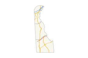
Delaware Route 36 (DE 36) is a state highway in Sussex County, Delaware. It runs in a generally northeast–southwest direction from DE 404 in Scotts Corner to Slaughter Beach, a town along the Delaware Bay. The road runs through the northern portion of Sussex County, passing through rural areas along Greenwood and Milford. The route intersects DE 16 and U.S. Route 13 (US 13) in Greenwood and US 113, DE 1 Business (DE 1 Bus.), and DE 1 in Milford. DE 36 was built as a state highway in stages during the 1920s and 1930s. The road was designated by 1938 from DE 16 east of Greenwood to Fort Saulsbury (present-day Slaughter Beach) and was extended west to DE 404 by 1994.
Route description
DE 36 begins at an intersection with DE 404 in Scotts Corner, heading the northeast on two-lane undivided Scotts Store Road. The road passes through a mix of farmland and woodland with some homes, coming to an intersection with DE 16. At this point, DE 16 turns east to run concurrent with concurrency with DE 36 on Hickman Road, passing through more farmland before entering Greenwood. The two routes continue east on Market Street, passing several homes along with a few businesses, and crosses Norfolk Southern's Delmarva Secondary railroad line. The road continues through more of the town before intersecting US 13 on the eastern edge of Greenwood. Past this intersection, DE 16/DE 36 leaves Greenwood and becomes Beach Highway, heading through rural areas with some development and crossing the Nanticoke River.[2][3]
In Saint Johnstown, DE 36 splits from DE 16 by heading to the northeast on Shawnee Road. The road heads through agricultural areas with some woods and homes. Farther northeast, the road reaches the city of Milford. Upon reaching Milford, the route heads through rural areas of homes and intersects US 113. Past this intersection, DE 36 becomes Lakeview Avenue and runs through residential areas, passing to the west of Bayhealth Milford Memorial hospital. The road passes to the east of Silver Lake, a lake along the Mispillion River, and crosses Norfolk Southern's Indian River Secondary railroad line. Past this, DE 36 continues to the east on Causey Avenue, passing homes and businesses. The route turns north onto Walnut Street briefly, heading into the downtown of Milford, before heading east on Southeast Front Street. The route heads through the residential eastern part of Milford where it intersects DE 1 Bus.[2][3]
DE 36 leaves Milford and heads to the northeast on Cedar Beach Road, entering a mix of farmland and homes. The road turns to the east, running a short distance to the south of the Mispillion River as it comes to a diamond interchange with the DE 1 bypass of Milford. Past this interchange, the route continues northeast through agricultural areas with some woods and residences. DE 36 winds east through a mix of farmland and marshland and comes to a drawbridge over the Cedar Creek in Slaughter Beach. The DE 36 designation ends here, but the road continues past the drawbridge into Slaughter Beach where it becomes Bay Avenue and turns south and runs along the Delaware Bay.[2][3]
DE 36 has an annual average daily traffic count ranging from a high of 9,886 vehicles at the eastern edge of Greenwood to a low of 871 vehicles at the eastern terminus.[1] None of DE 36 is part of the National Highway System.[4]
History
By 1920, a section of present-day DE 36 southwest of Milford was completed as a state highway while a portion leading further northeast into Milford was under contract as one; the remainder of the route existed as an unimproved county road.[5] The portion leading into Milford was completed by 1924, in addition to the segment of the road through Greenwood.[6] A year later, the state highway was under proposal between Greenwood and southwest of Milford.[7] The state highway between Greenwood and Milford was finished in 1929.[8] All of current DE 36 was completed by 1931 except for the easternmost part of the road.[9] DE 36 was designated to follow its current alignment between DE 16 east of Greenwood and Fort Saulsbury (now Slaughter Beach) by 1938, with the entire route paved except for the part near Fort Saulsbury.[10] The unpaved portion was paved by 1939.[11] DE 36 was extended westward to its current terminus at DE 404 by 1994.[12]
Major intersections
The entire route is in Sussex County.
| Location | mi[1] | km | Destinations | Notes | |
|---|---|---|---|---|---|
| Scotts Corner | 0.00 | 0.00 | |||
| Greenwood | 3.60 | 5.79 | West end of DE 16 overlap | ||
| 5.08 | 8.18 | ||||
| Saint Johnstown | 5.58 | 8.98 | East end of DE 16 overlap | ||
| Milford | 15.85 | 25.51 | |||
| 17.56 | 28.26 | ||||
| Interchange | |||||
| Slaughter Beach | 23.28 | 37.47 | Cedar Creek bridge | ||
| 1.000 mi = 1.609 km; 1.000 km = 0.621 mi | |||||
See also
- U.S. Roads portal
- Delaware portal
References
- ↑ 1.0 1.1 1.2 Staff (2011). "Traffic Count and Mileage Report: Interstate, Delaware, and US Routes" (PDF). Delaware Department of Transportation. Retrieved May 17, 2012.
- ↑ 2.0 2.1 2.2 Delaware Department of Transportation (2008). Delaware Official Transportation Map (PDF) (Map) (2008 ed.). Dover: Delaware Department of Transportation. Retrieved March 22, 2012.
- ↑ 3.0 3.1 3.2 Google (August 31, 2010). "overview of Delaware Route 36" (Map). Google Maps. Google. Retrieved August 31, 2010.
- ↑ National Highway System: Delaware (PDF) (Map). Federal Highway Administration. 2010. Retrieved February 10, 2012.
- ↑ Delaware State Highway Department (1920). Official Road Map (PDF) (Map) (1920 ed.). Dover: Delaware State Highway Department. Retrieved March 22, 2012.
- ↑ Delaware State Highway Department (1924). Official Road Map (PDF) (Map) (1924 ed.). Dover: Delaware State Highway Department. Retrieved March 22, 2012.
- ↑ Delaware State Highway Department (1925). Official Road Map (PDF) (Map) (1925 ed.). Dover: Delaware State Highway Department. Retrieved March 22, 2012.
- ↑ "Annual Report of the State Highway Department" (PDF) (1929 ed.). Dover, Delaware: Delaware State Highway Department. December 31, 1929. p. 19. Retrieved November 15, 2014.
- ↑ Delaware State Highway Department (1931). Official Road Map of the State of Delaware (PDF) (Map) (1931 ed.). Dover: Delaware State Highway Department. Retrieved March 22, 2012.
- ↑ Delaware State Highway Department; The National Survey Co. (1938). Official Road Map of the State of Delaware (PDF) (Map) (1938 ed.). Dover: Delaware State Highway Department. Retrieved March 22, 2012.
- ↑ Delaware State Highway Department (1939). Official Road Map of the State of Delaware (PDF) (Map) (1939 ed.). Dover: Delaware State Highway Department. Retrieved March 22, 2012.
- ↑ Delaware Department of Transportation; Division of Planning Cartographic Information Section (1994). Delaware Official State Map (PDF) (Map) (1994 ed.). Dover: Delaware Department of Transportation. Retrieved March 22, 2012.
External links
Route map: Bing
 Media related to Delaware Route 36 at Wikimedia Commons