Delaware Route 300
| ||||
|---|---|---|---|---|
 | ||||
| Route information | ||||
| Maintained by DelDOT | ||||
| Length: | 11.83 mi[1] (19.04 km) | |||
| Major junctions | ||||
| West end: |
| |||
|
| ||||
| East end: |
| |||
| Location | ||||
| Counties: | Kent | |||
| Highway system | ||||
| ||||

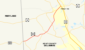
Delaware Route 300 (DE 300) is a 11.83-mile-long (19.04 km) state highway in Kent County, Delaware. The route is a continuation of Maryland Route 300 (MD 300) from the Maryland border near Everetts Corner. It runs in a northeast direction from there to Smyrna, where it ends at U.S. Route 13 (US 13) while concurrent with DE 6. Along the way, DE 300 passes through rural areas as well as the towns of Kenton and Clayton. The road intersects DE 44 in Everetts Corner, DE 11 southwest of Kenton, DE 42 in Kenton, DE 15 between Kenton and Clayton, and DE 6 in Smyrna. The road was first built as a state highway in the 1920s and 1930s between the Maryland border and Clayton, with the DE 300 designation given to the road by 1936. The route was extended to its current terminus in the 1950s.
Route description
DE 300 begins at the Maryland border, where it continues west into that state as MD 300. From the state line, the route heads east on two-lane undivided Sudlersville Road through agricultural areas. A short distance after the state line, the road intersects the western terminus of DE 44 in Everetts Corner. DE 300 continues east-northeast through farmland with some woods and residences, intersecting the northern terminus of DE 11. The route heads northeast, crossing an abandoned railroad line before entering Kenton. At this point, the road becomes Main Street and passes homes with a few businesses, intersecting DE 42 in the center of town.[2][3]
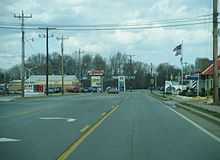
Past Kenton, DE 300 continues northeast on Wheatleys Pond Road, passing through more farm fields with some woodland and residences. The road forms a brief concurrency with DE 15 before heading north through farmland with residential subdivisions. DE 300 enters Clayton, running northeast through industrial areas and crossing Norfolk Southern's Delmarva Secondary railroad line. The route continues through a mix of homes and businesses, crossing into Smyrna and intersecting DE 6. At this point, DE 6 turns northeast and forms a concurrency with DE 300 on Glenwood Avenue. The two routes pass homes and businesses before entering a commercial area in the northern part of Smyrna. Here, the road widens into a divided highway before intersecting US 13. At this point, DE 300 ends and DE 6 turns southeast to form a concurrency with US 13.[2][3]
DE 300 has an annual average daily traffic count ranging from a high of 16,120 vehicles at the eastern terminus at US 13 to a low of 1,756 vehicles at the DE 11 intersection.[1] The portion of DE 300 between the Maryland border and DE 44 is part of the National Highway System.[4]
History
By 1920, what is now DE 300 existed as an unimproved county road.[5] The road was completed as a state highway between Kenton and Clayton and was proposed as one west of Kenton by 1924.[6] By 1931, the entire route between Clayton and the Maryland border was completed as a state highway.[7] When Delaware created its state highway system by 1936, DE 300 was routed on its current alignment between the Maryland border and an intersection with DE 6 between Clayton and Smyrna.[8] By 1954, DE 300 was extended east to its present terminus at US 13 in Smyrna.[9] By the 1990s, DE 6 was routed along DE 300 in Smyrna, bypassing the downtown area.[10]
Major intersections
The entire route is in Kent County.
| Location | mi[1] | km | Destinations | Notes | |
|---|---|---|---|---|---|
| 0.00 | 0.00 | Maryland state line, western terminus | |||
| Everetts Corner | 0.33 | 0.53 | |||
| 4.54 | 7.31 | ||||
| Kenton | 5.32 | 8.56 | |||
| West end of DE 15 overlap | |||||
| East end of DE 15 overlap | |||||
| Smyrna | 10.73 | 17.27 | West end of DE 6 overlap | ||
| 11.83 | 19.04 | Eastern terminus | |||
| 1.000 mi = 1.609 km; 1.000 km = 0.621 mi | |||||
See also
- U.S. Roads portal
- Delaware portal
References
- ↑ 1.0 1.1 1.2 Staff (2011). "Traffic Count and Mileage Report: Interstate, Delaware, and US Routes" (PDF). Delaware Department of Transportation. Retrieved May 17, 2012.
- ↑ 2.0 2.1 Delaware Department of Transportation (2008). Delaware Official Transportation Map (PDF) (Map) (2008 ed.). Dover: Delaware Department of Transportation. Retrieved March 22, 2012.
- ↑ 3.0 3.1 Google (August 22, 2010). "overview of Delaware Route 300" (Map). Google Maps. Google. Retrieved August 22, 2010.
- ↑ National Highway System: Delaware (PDF) (Map). Federal Highway Administration. 2010. Retrieved February 10, 2012.
- ↑ Delaware State Highway Department (1920). Official Road Map (PDF) (Map) (1920 ed.). Dover: Delaware State Highway Department. Retrieved March 22, 2012.
- ↑ Delaware State Highway Department (1924). Official Road Map (PDF) (Map) (1924 ed.). Dover: Delaware State Highway Department. Retrieved March 22, 2012.
- ↑ Delaware State Highway Department (1931). Official Road Map of the State of Delaware (PDF) (Map) (1931 ed.). Dover: Delaware State Highway Department. Retrieved March 22, 2012.
- ↑ Delaware State Highway Department; The National Survey Co. (1936). Official Road Map of the State of Delaware (PDF) (Map) (1936–37 ed.). Dover: Delaware State Highway Department. Retrieved March 22, 2012.
- ↑ Delaware State Highway Department (1954). Official Highway Map of Delaware (PDF) (Map) (1954–55 ed.). Dover: Delaware State Highway Department. Retrieved March 22, 2012.
- ↑ Delaware Department of Transportation; Division of Planning Cartographic Information Section (1996). Delaware Official State Map (PDF) (Map) (1996 ed.). Dover: Delaware Department of Transportation. Retrieved March 22, 2012.
External links
Route map: Bing
 Media related to Delaware Route 300 at Wikimedia Commons