Deep Creek Hot Springs
| Deep Creek Hot Springs | |
|---|---|
 | |
| Location | San Bernardino County, California, USA |
| Nearest city | Hesperia |
| Coordinates | 34°20′22″N 117°10′37″W / 34.33944°N 117.17694°WCoordinates: 34°20′22″N 117°10′37″W / 34.33944°N 117.17694°W |
| Governing body |
San Bernardino National Forest, United States Forest Service |
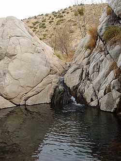
Deep Creek Hot Springs, DCHS, are natural hot springs located in the northern Mojave Desert section of the San Bernardino National Forest, near Hesperia in San Bernardino County, Southern California.[1]
Geography
The springs are in the rain shadowed desert foothills of the San Bernardino Mountains on the Deep Creek fork of the Mojave River. They are in a large bouldered riparian zone, surrounded by a rich habitat ecotone of the xeric shrublands—desert chaparral, montane chaparral and woodlands, and conifer forest plant communities.[1]
The Southwestern Arroyo Toad—Bufo californicus, an endangered species, lives along Deep Creek.[1][2]
Recreation
Deep Creek Hot Springs, being located next to Deep Creek, provides both hot and cold water locations for clothing optional bathing. The site is managed by the San Bernardino National Forest.[1] Water from the creek or pools is not advised for consumption without treatment or filtering, and bringing sufficient drinking water is advised.[1] Freedom Trail reaches Deep Creek Hot Springs, and The Pacific Crest Trail along the creek crosses the area.[1]
Directions
- Interstate 15 to the Bear Valley exit in Victorville.
- Bear Valley (east) proceeding ten miles (16 km) to Central.
- Right on Central (south) proceeding three miles (past railroad tracks and over a steep hill) to Ocotillo.
- Left (east) on Ocotillo proceeding 2.2 miles (3.5 km) to Bowen Ranch Road (after it becomes dirt surfaced).
- Right (south) on Bowen Ranch Road, proceeding approximately six miles to Bowen Ranch ($5 to $10 per person fee) parking and trailhead.
- The hike, approximately two miles, drops over 900 feet (270 m) in altitude. Some parts of the trail are rough, with sturdy hiking boots advised.
- or
- Pacific Crest Trail (free), a six mile hike east from the trailhead at Arrowhead Lake Road.
- Directions to deep creek hot springs via freedom trail
from the L.A. area take the 15 fwy north exit main st turn right and go 7.1 miles and turn left onto to rock springs rd. as you pass Kiowa rd., rock springs turn into round up way, continue on round up way another 2 miles, the road turns from pavement to dirt. Zero out your odometer when the road turn to dirt and continue on to Bowen ranch road (JF3310), make a right onto Bowen ranch rd. you will come to one big fork in the road just stay to your right and keep driving at about 4.7 mi you’ll pass round mountain ranch and cross over a cattle guard . At around 6 miles you will come up on a fork in the road, the entrance to Bowen ranch on the left and the road to freedom trail on the right (JF 4325). The road to the right looks really scary but it’s not that bad and it’s only that bad in the beginning. Any suv or med to high clearance vehicle will be fine even small cars can do this if they drive smart. At around at 7 miles you will come up on a fork in the rd. keep left onto (JF 3320) at around 7.5 miles the barbwire fence will come up on your left again the road goes uphill and at about 8 miles starts downhill, take this slow it’s a little tricky and rough. The next left will be coming up shortly after at around 8.3 miles, continue on around 8.7miles you’ll come to the last tough spot a small uphill stay to the right and keep moving the parking area is another 100 yards down the hill 8.8 mi and the trail begins to the right . It’s a very easy trail to follow but a little steep challenging just like Bowen ranch only 1 mile to the hot springs and no ridiculous fee of $5 per person. Please know your limits bring and plenty of water.
Regulations
The Deep Creek Hot Springs regulations include:[1]
- Closed to the public from sundown to sunrise
- Public nudity is not permitted within 1/4 mile of 'T-6 crossing.' The T-6 crossing is located upstream from the steel bridge near Splinter's Cabin. This is actually 10 miles up steam from Deep Creek Hot Springs.[3]
- No camping is permitted within 1-mile (1.6 km) of Deep Creek.
- No fire, campfires or stoves allowed in the Deep Creek drainage basin.
- No glass containers permitted within 1-mile (1.6 km) of Deep Creek
- Pack out all refuse.
- State designation Wild Trout Stream, the Deep Creek Wild Trout Area
See also
References
External links
- U.S. Geological Survey Geographic Names Information System: Deep Creek
- San Bernardino National Forest: official Deep Creek Hot Springs website
- Deep Creek Hot Springs.net Forum
- Deep Creek Hot Springs Yahoo Group forum (Yahoo login required)
- Deep Creek Volunteers
- Deep Creek Hot Springs: location photo gallery
- Detailed directions to Deep Creek Hot Springs and photo gallery