Dead Man's Curve
For other uses, see Dead Man's Curve (disambiguation).
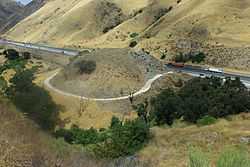
A section of the 1915 Ridge Route in Lebec, California, abandoned when US 99 (later upgraded to I-5) was constructed over the Tejon Pass in order to make travel straighter and safer.
A Dead Man's Curve is a crescent or horseshoe-shaped section of a road that has claimed lives because of numerous traffic crashes. The term is in common use in the United States, while the related term hairpin turn is more widely used in other parts of the world.
United States
Alabama
- Interstate 20 east of the Birmingham International Airport, at its junction with Interstate 59; engineers built a curve into the highway to avoid a cemetery.[1]
- Interstate 59 about 8 miles north of Gadsden. The S-shaped curve was built to avoid running into a steep mountain.
- A sharp turn in a series of sharp bends on Kali Oka Road, in Saraland, just south of a Crybaby Bridge.
California
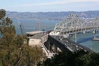
An S-shape connector on the San Francisco–Oakland Bay Bridge, as seen on September 29, 2009, from the U.S. Coast Guard station on Yerba Buena Island
- A temporary S-shape curve on the eastern span of the San Francisco–Oakland Bay Bridge (part of Interstate 80). After its installation on September 8, 2009, to divert traffic as part of a replacement project, 43 accidents took place, including one fatal crash.[2]
- A sharp turn in the shape of a "U" on SR 76 in San Diego County, near Red Gate Road.[3] The curve has claimed the lives of many motorcyclists.
- A stretch of Sunset Boulevard in Los Angeles was memorialized by Jan and Dean in the song "Dead Man's Curve." It is located near the Bel Air estates north of UCLA's Drake Stadium. While an accident involving voice actor Mel Blanc prompted safety improvement, the curve remains today.[4][5]
Colorado
- A sharp turn on eastbound Interstate 70 near Morrison that is preceded by a seven-mile (11 km) stretch of a 6.5% grade downslope, which has been the site of numerous fatal runaway truck accidents.[6][7]
Hawaii
- A sharp turn at the end of Kapaa Quarry Road, which is a dimly lit utility road in Kailua. Honolulu County, that has claimed eight fatalities and is considered one of Oahu's haunted roads.[8][9]
Illinois
- In Towanda, Illinois, an almost 90-degree Dead Man's Curve on the original Old U.S. Route 66 was the site of many accidents; a number of which ended in fatalities. The roadbed was eventually turned into a park and walking trail.[10]
Indiana
- In Indianapolis, a curve on Interstate 70 westbound at mile marker 83.1[11] When opened, it had a negative camber on the right shoulder, and several truckers lost control and hit the a bridge abutment, losing their lives. The stretch was closed, re-engineered with a positive bank and with rain slots along the boundary and was reopened with a 40 mph speed limit.
Kentucky
- A treacherous stretch of Interstate 75 in Northern Kentucky, originally known as "Death Hill" and now known as "Cut-in-the-Hill."[12]
Louisiana
- In northern Bossier Parish, a sharp curve on Louisiana 157 (Hickory Drive), just inside the city limits of Plain Dealing, south of the town cemetery.[13]
Maryland
- Interstate 83 (Jones Falls Expressway) in Baltimore.[14]
Michigan
- In Marquette Township, Marquette County, Dead Man's Curve referred to a curve on County Road 492 (previously a part of M-15), where the first centerline in the United States was painted.[15] Geographical coordinates: 46°31′54″N 87°28′26″W / 46.5318°N 87.474°W
- In Milford, MI, Oakland County 42°33'37.4"N 83°35'50.0"W
Missouri
- Sharp turn on Missouri State Route 34 just east of Garwood, in Reynolds County.
- Missouri letter Hwy A in Franklin County between Washington and Krakow. Geographical coordinates: 38°31′14″N 91°02′14″W / 38.520580°N 91.037139°W
New Mexico
- Near Mesita, New Mexico, a 180 degree bend in the road to the left on Historic U.S. Route 66 nicknamed "Dead Man's Curve."[16]
- Between Albuquerque, New Mexico and Tijeras, New Mexico, State Road 333 (Previously known as U.S. Route 66)makes a sudden curve near the I-40 overpass. This stretch of highway has earned its name because of the rocky cliffs on the south side of the highway, and frequent deer traffic contributes to its hazardousness[17][18][19]
New York
- A 90-degree turn on New York State Route 17 in Binghamton, near the junction with Interstate 81 and Interstate 88, which also goes by the name Kamikaze Curve. The tight curve, which hugs Prospect Mountain along the Chenango River, is slated for improvements as part of NY 17's upgrade to Interstate 86.
Ohio

Dead Man's Curve in Cleveland, Ohio
- The nearly 90-degree turn on Interstate 90 near downtown Cleveland, officially called the "Innerbelt Curve",[20] at the point where the Cleveland Memorial Shoreway connects to the Innerbelt Freeway at a modified trumpet interchange just south of Burke Lakefront Airport.[21][22] The advisory speed is 35 miles per hour (60 kilometers per hour), although the maximum speed limit is 50 mph (80 km/h), as on adjacent sections of the Shoreway and Innerbelt.[23] Location: 41°31′02″N 81°40′31″W / 41.5173°N 81.6754°W
- Dead Man's Curve was constructed as part of the Innerbelt project in 1959.[24] At the time, Interstate 90 had been planned to continue westward on the Shoreway, connecting with its current location via the never-built Parma Freeway.[25] It soon became apparent that the curve was too sharp for travel at typical Interstate speeds, and in 1965, the state lowered the speed limit from 50 mph (80 km/h) to 35 mph (56 km/h). Four years later, authorities completed the first set of safety retrofits, which included banking the curve and installing rumble strips and large signs.[26]
- According to the Ohio Department of Transportation (ODOT), the crash rate on the Innerbelt (which includes Dead Man's Curve) is two to three times the regional average for urban freeways, despite the reduced speed limits on the roadway. The department has investigated ways of enhancing safety on the stretch, including a complete realignment of the roadway to reduce the degree of the curve.[27][28] As of 2014 the proposed configuration of the curve as presented in the ODOT Innerbelt Plan[20] is still planned to be built but not until the mid-2020s.[29][30] According to a 2013 ODOT count, 64,720 vehicles travel on the curve every day.[31]
- A sharp bend in U.S. Route 50 (Columbia Parkway) east of Cincinnati, Ohio.[32]
- Sharp turn 5 on Interstate 75 just north of downtown Dayton.[33]
Oregon
- On the Mount Hood Scenic Byway between Zigzag and Government Camp[34]
Pennsylvania
- The northern terminus of Interstate 476 in Clarks Summit is a 180-degree turn, with an advisory speed limit of 20 mph, created in order to access a toll plaza before the interchange with Interstate 81.
- On U.S. Route 22 in Easton, there are several dangerous sharp turns that go past a graveyard.[35] (This is most commonly known as "Cemetery Curve" for that reason.) Streetlights were installed to help cut down on nighttime crashes; the lightposts are themselves frequent victims of collisions.[36]
Texas
- A sharp, sudden turn on U.S. Route 175 (C. F. Hawn Freeway) at the interchange with SH 310 southeast of downtown Dallas.[37] After a fatal truck accident in 2008, the state installed additional beacons and also flashing chevrons to further draw motorists' attention to the hazard. As of 2010, the department of highways is studying plans to eliminate this curve by extending the C. F. Hawn Freeway westward to Interstate 45.
Netherlands
Zoomweg
See also
- Hairpin curve
References
- ↑ Google Maps view of curve in Birmingham
- ↑ Lee, Henry K.; Michael Cabanatuan & Jaxon Van Derbeken (November 10, 2009). "Changes coming to Bay Bridge after death plunge". San Francisco Chronicle. Retrieved November 11, 2009.
- ↑ Google Maps view of curve in San Diego County
- ↑ Snopes.com page regarding the Los Angeles curve
- ↑ Google Maps view of curve in Los Angeles (Sunset Blvd)
- ↑ Google Maps view of curve in Colorado
- ↑ Gathright, Alan (2007-07-12). "Stretch of I-70 has deadly legacy". Rocky Mountain News. Archived from the original on 2007-07-14. Retrieved 2007-07-13.
- ↑ http://www.hauntedhawaii.net/ghost_hunting___3.170.html#Ghost%20Hunting%20-%203
- ↑ http://www1.honolulu.gov/refs/nco/nb31/08/31febmin.htm
- ↑ "The Mother Road: Historic Route 66 - Dead Man's Curve". Retrieved 5 October 2014.
- ↑ Google Maps view of I70 west at mile marker 83.1 in Indianapolis
- ↑ Google Maps view of curve in Covington, Kentucky
- ↑ Google Maps view of curve in Plain Dealing
- ↑ Google Maps view of curve in Baltimore
- ↑ Kulsea, Bill; Shawver, Tom (1980). Making Michigan Move: A History of Michigan Highways and the Michigan Department of Transportation. Lansing, MI: Michigan Department of Transportation. p. 10.
- ↑ "The Mother Road: Historic Route 66 - Turn by Turn Road Description - New Mexico". Retrieved 5 October 2014.
- ↑ 2
- ↑ "Google Maps". Retrieved 5 October 2014.
- ↑ "New Mexicans move to make roads more wildlife-friendly". Retrieved 5 October 2014.
- ↑ 20.0 20.1 Chapter 4.0: Conceptual Alternatives – Innerbelt Curve, Cleveland Innerbelt: Conceptual Alternatives Study, Ohio Department of Transportation/Burgess & Niple/URS Corporation, 2006-08-11. Retrieved 2012-07-22.
- ↑ "Encyclopedia of Cleveland History — Innerbelt Freeway". Retrieved 5 October 2014.
- ↑ Google Maps view of curve in Cleveland
- ↑ Ohio Department of Transportation (2007-05-16). District 12 Speed Zones. p. 5.
- ↑ Sweeney, James (2001-04-22). "Dead Man's Curve could be worse - in fact, it was". The Plain Dealer.
- ↑ Ohio Department of Highways. "1957-1958 Biennial Report excerpt". Retrieved 2012-07-22.
- ↑ Cabanatuan, Michael (2009-11-11). "Ideas offered to slow S-curve motorists". San Francisco Chronicle. Retrieved 2009-11-11.
- ↑ Sweeney, James (2001-04-22). "Roadblock to improving safety; Inner Belt changes being studied, but Dead Man's Curve might be dead end". The Plain Dealer.
- ↑ Marshall, Aaron (2012-07-22). "Cleveland's Dead Man's Curve Not Going to Stop Tipping Trucks Anytime Soon". The Plain Dealer. Retrieved 2012-07-22.
- ↑ Contract Group 4, Innerbelt Plan
- ↑ Grant, Alison (2014-08-12). "Traffic Congestion Easing across Northeast Ohio". The Plain Dealer. Retrieved 2014-08-13.
- ↑ Cuyahoga County Annual Average Daily Traffic 2013 (Map). Ohio Department of Transportation. 2013.
- ↑ Google Maps view of curve in Cincinnati
- ↑ Google Maps view of curve in Dayton
- ↑ Google Maps view of curve in on the Mount Hood Scenic Byway
- ↑ Google Maps view of curve in Easton
- ↑ "Shine the lights on Cemetery Curve; Tuesday will be a great day for no-shows - Oct. 28 letters to the editor". Easton Express-Times. 2010-10-28. Retrieved 2010-12-15.
- ↑ Google Maps view of curve in Dallas
- ↑ Google Maps view of curve in Zoomweg