Dduallt
This article is about the mountain in Snowdonia. For the station on the Ffestiniog Railway, see Dduallt railway station.
| Dduallt | |
|---|---|
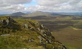 Arenig Fawr and Moel Llyfnant from Dduallt summit | |
| Elevation | 662 m (2,172 ft) |
| Prominence | 138 m (453 ft) |
| Listing | Hewitt, Nuttall, HuMP |
| Translation | Black hill (Welsh) |
| Pronunciation | Welsh: [ˈðɨæɬt] |
| Location | |
| Location | Gwynedd, Wales |
| Range | Snowdonia |
| OS grid | SH810273 |
Dduallt (English: Black hill) (pronounced [ðɨ.æɬt]) is a mountain in central Snowdonia, North Wales. It is the sister peak of Rhobell Fawr.
It lies north of the A494 between Dolgellau and Llanuwchllyn. Its eastern slopes are the source of the River Dee.[1]
References
- ↑ Nuttall, John & Anne (1999). The Mountains of England & Wales - Volume 1: Wales (2nd edition ed.). Milnthorpe, Cumbria: Cicerone. ISBN 1-85284-304-7.
External links
- Dduallt is at coordinates 52°49′49″N 3°45′57″W / 52.830198°N 3.765779°WCoordinates: 52°49′49″N 3°45′57″W / 52.830198°N 3.765779°W
- www.geograph.co.uk : photos of Dduallt and surrounding area