Day, Minnesota
| Day, Minnesota | |
|---|---|
| Unincorporated community | |
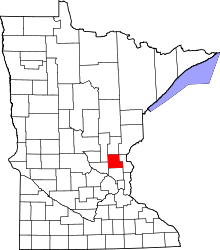
 Day, Minnesota Location of the community of Day | |
| Coordinates: 45°42′33″N 93°22′46″W / 45.70917°N 93.37944°WCoordinates: 45°42′33″N 93°22′46″W / 45.70917°N 93.37944°W | |
| Country | United States |
| State | Minnesota |
| County | Isanti |
| Township | Maple Ridge Township |
| Elevation | 1,033 ft (315 m) |
| Time zone | Central (CST) (UTC-6) |
| • Summer (DST) | CDT (UTC-5) |
| ZIP code | 55006 |
| Area code(s) | 320 |
| GNIS feature ID | 642660[1] |
Day is an unincorporated community in Maple Ridge Township, Isanti County, Minnesota, United States.
Isanti County Roads 4 and 22 are two of the main routes in the community. Nearby places include Dalbo, Coin, Braham, Lewis Lake, and Cranberry Wildlife Management Area. State Highway 47 (MN 47) is nearby.
References
- Official State of Minnesota Highway Map – 2013/2014 edition
| |||||||||||||||||||||||||||||||||