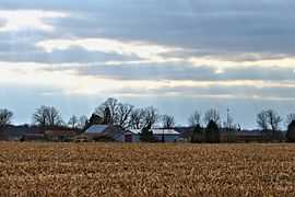
Dawn-Euphemia
Dawn-Euphemia is a township in southwestern Ontario, Canada, in Lambton County. Residents primarily are employed by the agricultural industry, or by local industries such as Union Gas distribution centre, along with various smaller agricultural manufacturers or service providers. The township municipal office is located in Rutherford.
Major transportation routes include Cairo Road and Oil Heritage Road directed North-South and Bentpath Line and Lambton Line running East-West. One elementary school serves the area, Dawn-Euphemia School. Students attend secondary school in nearby Petrolia and Dresden, both of which serve as local service centres for residents.
Communities
The township comprises the communities of Aberfeldy, Aughrim, Beaver Meadow, Bentpath, Cairo, Cuthbert, Dawn, Dawn Valley, Edys Mills, Florence, Garville, Huffs Corners, Lambton, Langbank, Oakdale, Rutherford and Shetland.
Demographics
Canada census – Dawn-Euphemia community profile |
|---|
| | | 2011 | 2006 | 2001 | |
Population:
Land area:
Population density:
Median age:
Total private dwellings:
Median household income:
|
2049 (-6.4% from 2006)
445.13 km2 (171.87 sq mi)
4.6/km2 (12/sq mi)
43.1 (M: 42.2, F: 44.1)
866
|
2190 (-7.6% from 2001)
445.05 km2 (171.83 sq mi)
4.9/km2 (13/sq mi)
40.9 (M: 40.5, F: 41.1)
869
$49,451
|
2369 (-8.1% from 1996)
445.05 km2 (171.83 sq mi)
5.3/km2 (14/sq mi)
38.4 (M: 38.3, F: 38.5)
905
$44,996
|
| | |
|
Historic populations:[3][4]
- Population in 2001: 2369
- Population total in 1996: 2577
- Dawn (township): 1595
- Euphemia (township): 982
- Population in 1991:
- Dawn (township): 1687
- Euphemia (township): 1017

Rural countryside of Dawn-Euphemia
See also
References


