Davis Township, Fountain County, Indiana
| Davis Township | |
|---|---|
| Township | |
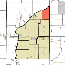 Location of Davis Township in Fountain County | |
| Coordinates: 40°18′27″N 87°07′42″W / 40.30750°N 87.12833°WCoordinates: 40°18′27″N 87°07′42″W / 40.30750°N 87.12833°W | |
| Country | United States |
| State | Indiana |
| County | Fountain |
| Government | |
| • Type | Indiana township |
| Area | |
| • Total | 23.71 sq mi (61.4 km2) |
| • Land | 23.54 sq mi (61.0 km2) |
| • Water | 0.17 sq mi (0.4 km2) |
| Elevation[1] | 712 ft (217 m) |
| Population (2010) | |
| • Total | 682 |
| • Density | 29/sq mi (11/km2) |
| FIPS code | 18-16912[2] |
| GNIS feature ID | 453253 |
Davis Township is one of eleven townships in Fountain County, Indiana, United States. As of the 2010 census, its population was 682 and it contained 286 housing units.[3]
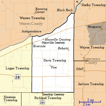
Geography
According to the 2010 census, the township has a total area of 23.71 square miles (61.4 km2), of which 23.54 square miles (61.0 km2) (or 99.28%) is land and 0.17 square miles (0.44 km2) (or 0.72%) is water.[3] It contains no incorporated settlements but four unincorporated ones. Both Maysville Crossing and Riverside lie in the northwest part of the township along the Norfolk Southern Railway line; Riverside is across the Wabash River from Independence in neighboring Warren County. Roberts is in the eastern part of the township, and Vine is near the center.
Indiana State Road 28 crosses the south part of the township from east to west.[4] Indiana State Road 341 begins at State Road 28 and runs south.[5]
Cemeteries
The township contains Maysville Cemetery, to the southwest of Maysville Crossing.[6]
References
- ↑ "US Board on Geographic Names". United States Geological Survey. 2007-10-25. Retrieved 2008-01-31.
- ↑ "American FactFinder". United States Census Bureau. Retrieved 2008-01-31.
- ↑ 3.0 3.1 "Population, Housing Units, Area, and Density: 2010 - County -- County Subdivision and Place -- 2010 Census Summary File 1". United States Census. Retrieved 2013-05-10.
- ↑ "State Road 28". Highway Explorer. Retrieved 2010-09-21.
- ↑ "State Road 341". Highway Explorer. Retrieved 2010-09-21.
- ↑ "Maysville Cemetery". Geographic Names Information System. United States Geological Survey. Retrieved 2011-09-05.
- "Davis Township, Fountain County, Indiana". Geographic Names Information System. United States Geological Survey. Retrieved 2009-09-24.
- United States Census Bureau cartographic boundary files
External links
 |
Warren Township, Warren County | |
Shelby Township, Tippecanoe County Wayne Township, Tippecanoe County |
|
| Logan Township | |
|||
| ||||
| | ||||
| Richland Township | Jackson Township, Tippecanoe County |
| |||||||||||||||||||||||||