Daventry District
| Daventry District | |
|---|---|
| District | |
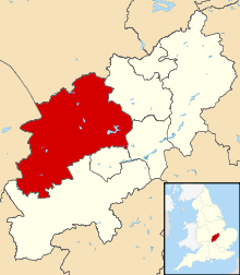 Shown within Northamptonshire | |
| Sovereign state | United Kingdom |
| Constituent country | England |
| Region | East Midlands |
| Administrative county | Northamptonshire |
| Admin. HQ | Daventry |
| Government | |
| • Type | Daventry District Council |
| • Leadership: | Alternative - Sec.31 |
| • Executive: | Conservative |
| • MP: | Chris Heaton-Harris |
| Area | |
| • Total | 255.8 sq mi (662.6 km2) |
| Area rank | 58th |
| Population (2011 est.) | |
| • Total | 78,100 |
| • Rank | Ranked 290th |
| • Density | 310/sq mi (120/km2) |
| Time zone | Greenwich Mean Time (UTC+0) |
| • Summer (DST) | British Summer Time (UTC+1) |
| ONS code |
34UC (ONS) E07000151 (GSS) |
| Ethnicity | 98.0% White |
| Website | daventrydc.gov.uk |
The Daventry district is the largest local government district of western Northamptonshire, England. The district is named after the town of Daventry which is the administrative headquarters and largest town. The district is predominantly rural, other significant settlements include Brixworth, Long Buckby and Weedon Bec.
The Daventry district was created on 1 April 1974, under the Local Government Act 1972, by a merger of the historic municipal borough of Daventry, with the Daventry Rural District and most of the Brixworth Rural District. The town of Daventry became an unparished area with Charter Trustees and remained so until 2003 when a civil parish was created, roughly corresponding with the boundaries of the former borough, so allowing Daventry to have its own town council.[1]
- Settlements in Daventry district
- Althorp, Arthingworth, Ashby St Ledgers
- Badby, Barby, Boughton, Braunston, Brington, Brixworth, Brockhall, Byfield
- Canons Ashby, Chapel Brampton, Charwelton, Church Brampton, Church Stowe, Clay Coton Clipston, Cold Ashby, Coton, Cottesbrooke, Creaton, Crick
- Daventry, Dodford, Draughton
- East Farndon, East Haddon, Elkington, Everdon
- Farthingstone, Fawsley, Flore
- Great Brington, Great Oxendon, Guilsborough
- Hanging Houghton, Hannington, Harlestone, Haselbech, Hellidon, Holcot, Holdenby, Hollowell
- Kelmarsh, Kilsby
- Lamport, Lilbourne, Little Brington, Long Buckby, Lower Catesby
- Maidwell, Marston Trussell, Moulton
- Naseby, Newnham, Norton
- Old, Overstone
- Pitsford, Preston Capes
- Ravensthorpe
- Scaldwell, Sibbertoft, Spratton, Stanford-on-Avon, Staverton, Sulby
- Teeton, Thornby
- Upper Catesby, Upper Stowe
- Walgrave, Watford, Weedon Bec, Welford, Welton, West Haddon, Whilton, Winwick, Woodford Halse
- Yelvertoft
- Historical settlements
Energy policy
In May 2006, a report commissioned by British Gas[2] showed that housing in the district of Daventy produced the 7th highest average carbon emissions in the country at 7,276 kg of carbon dioxide per dwelling.
See also
References
| ||||||||||||||||||||||||||
| ||||||||||||||||||||||||||||