Datia district
| Datia district दतिया जिला | |
|---|---|
| District of Madhya Pradesh | |
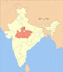 Location of Datia district in Madhya Pradesh | |
| Country | India |
| State | Madhya Pradesh |
| Administrative division | Gwalior division |
| Headquarters | Datia |
| Tehsils | Datia Seondha and Bhander |
| Government | |
| • Lok Sabha constituencies | Bhind lok sabha constituency |
| • Assembly seats | Datia Seondha and Bhander |
| Area | |
| • Total | 2,902 km2 (1,120 sq mi) |
| Population (2011) | |
| • Total | 786,754 |
| • Density | 270/km2 (700/sq mi) |
| • Urban | 181,976 |
| Demographics | |
| • Literacy | 72.63 per cent |
| • Sex ratio | 873 |
| Major highways | N75 |
| Website | Official website |
Datia District (Hindi: दतिया जिला) is in Gwalior Division in the Indian state of Madhya Pradesh. The town of Datia is the district headquarters.
History
It is an ancient town, mentioned in the Mahabharata as Daityavakra.Datia had formerly been a state in the bundelkhand region.The ruling family were Rajputs of the Bundela clan; they descended from a younger son of a former raja of Orchha. The state was administered as part of the Bundelkhand agency of Central India. It lay in the extreme north-west of Bundelkhand, near Gwalior, and was surrounded on all sides by other princely states of Central India, except on the east where it bordered upon the United Provinces.[1] It was second highest in the rank of all the Bundela states after Orchha, with a 15-gun salute, and its Maharajas bore the hereditary title of Second of the Princes of Bundelkhand. The land area of the state was 2130 mi² its population in 1901 was 173,759.[1]
Datia, together with the rest of the Bundelkhand agency, became part of the new state of Vindhya Pradesh in 1950. In 1956, Vindhya Pradesh state was merged with certain other areas to form the state of Madhya Pradesh within the Union of India.
Geography
In 2011, Datia had population of 786,754 of which male and female were 420,157 and 366,597 respectively The district has an area of 2,902 km², and a population 627,818 (2001 census). The population of Datia District increased by 26% from 1981 to 1991, and by 22% from 1991 to 2001. The district has 445 villages and 3 towns, Datia, Seondha, and Bhander. Each town is the headquarters of its tehsil.[2]
Datia is bounded by the Madhya Pradesh districts of Bhind to the north, Gwalior to the west, and Shivpuri to the south, and by Jhansi District of Uttar Pradesh state to the east. The district is part of Gwalior Division.[2]

Tourist Places
Datia also has some famous temples. 'Peetambra Peeth' is one such temple which attracts a lot of pilgrims, apart from Hanuman garhi. 'Purana Mahal or Datia Mahal' is one good piece of architecture, visible from the railway line passing from Gwalior to Jhansi and was built to welcome King Jahangir after his coronation but the Emperor never came, fearing he would have to give good reward to king of Datia for his help in getting the Moghul throne.some of other torist spot are ratangath mata,Sonagiri-Temples, Shri Sidh Baba Mandir Kurthata, Beer Singh Deo Mahal,Unao-Balaji Sun Temple,Rajgarh Palace & Museum and Gujarra etc.
Drainage
The Datia district comes under the Gangetic drainage system and is drained by the Sindh, the Pahuj, the Mahuar and the Betwa. The former two, however form the drainage system of the main body of the district. The rivers are almost seasonal and have heavy run off only during the peak period of July and August in the rainy season. During the dry season most of the streams become dry and water is available only in some channels of the main stream.
Demographics
Population
According to the 2011 census Datia District has a population of 786,754[3] roughly equal to the nation of Comoros[4] or the US state of South Dakota.[5] This gives it a ranking of 487th in India (out of a total of 640).[3] The district has a population density of 271 inhabitants per square kilometre (700/sq mi) .[3] Its population growth rate over the decade 2001-2011 was 18.4%.[3] Datia has a sex ratio of 873 females for every 1000 males,[3] and a literacy rate of 72.63%.[3] Out of the total Datia population for 2011 census, 23.13 percent lives in urban and 76.87 percent lives in rural (village)regions of district.[3]
Languages
Main language is khadiboli bundeli bt some other local language also Vernaculars include Bharia, a Dravidian language spoken by at least 200 000 members of the Bharia tribe and written in the Devanagari script.[6]
Religion
According to census of 2011, 96% of the datia residents followed Hinduism, while others are 4%
Culture
There are lot of way of entertainment in Datia
Music
There are Bundelkhandi lookgeet,faag,alha kabbali the main music.you can hear all these in any village of datia district and famous singer are Mr. Rajendera singh Gurjar and Mr. Deshraj pateriya Jee.
Dance
RAI is the famous dance here and some of the famous female dancer are Mrs.HINA RANI & Team and Mrs. Guiya Rani & Team
kushti(wrestle)
Kusti is famous amusement and also a passion between citizen in datia.Wrestlers are called as PAHALWAN. Gama was a famous pahalwan of Datia. He won in india and also in abroad.
Economy
Agriculture is main way of economy in datia 70% population depend upon the agriculture and other 30% depend in service Agro solvent is main factory running here which gives employment the poor peoples.
Transport
The district is traversed by the West Central Railway line between delhi and bhopal.This is also connected by the top cities of india by national highway N75
Education
According to census 2011 datia has 750 primary 500 middle and 250 high school.some of the famous are
- Principal, P.G. College Datia
- Principal, P.G.College(Girls) Datia
- Principal, Govind P.G.D.C Seondha
- Principal, P.G College, Bhander
- Principal, H.S.S No. 1 Datia 233113
- Principal, H.S.S No. 2 Datia 233290
- Principal, M.L.B Girls H.S.S. Datia
- Principal, H.S.S. Basai
- Principal, H.S.S. Unao
- Principal, H.S.S. Badoni
- Principal, H.S.S. Beekar
- Principal, H.S.S. Uprain
- Principal, H.S.S. Erai
- Principal, H.S.S.(Boys), Indergarh
- Principal, H.S.S.(Girls), Indergarh
- Principal, H.S.S. Uchad
- Principal, H.S.S. (Boys) Seondha
- Principal, H.S.S. (Girls) Seondha
- Principal, H.S.S. Tharet
- Principal, H.S.S. Bhaguwapura
- Principal, High School, Raruarai
- Principal, H.S.Civil Line Datia
- Principal, H.S.S. Budheda
- Principal, High School, Badonkala
- Principal, High School, Bardhuwa
- Principal, High School, Godan
- Principal, H.S.S.(Boys) Bhander
- Principal, H.S.S.(Girls) Bhander
- School of excellence datia
- Aspirant International School (Dedicated to Change Your Luck)
- Saraswati Vidya Mandir Bharatgarh
- Holy Cross Ashram School
- Rani Laxmibai Public School
- Little Flower School, Rajgarh Choraha
- Government Higher Secondary School No.1
- Government Higher Secondary School No 2
- Government Girl School
- Rajeev Vidyalaya
- Mahila Samiti School
- Rass JB professional studies
- Bhaskar School(OP Gupta) in Bundela colony
- College of Advanced Studies
- St. Kolbe School, Indergarh
- Gurukul public school
- Lord Krishna Public School
- Awasthi Computer Center
- Guidance public school Indergarh
- Vidyaashray School Indergarh 9827210405
- Under the single umbrella of SRI there are five colleges providing world class education in various disciplines i.e. engineering, pharmacy, BEd and D.Ed., nursing and allied sciences. All the institutes and colleges are set up and run by Shri Ramraja Sarkar Lok Kalyan Trust, an autonomous foundation which is a registered, charitable trust functioning through a Board of Governors and a Board of Trustees.
- Shri Rawatpura Group of Colleges (SRGOC) consists the following institutions:[7]-
- Shri Rawatpura Institute of Technology & Science (SRITS)
- Shri Rawatpura Institute of Management Sciences (SRIMS)
- Shri Rawatpura Institute of Pharmacy (SRIP)
- Shri Rawatpura College of Nursing (SRCN)
- Shri Rawatpura College of Physical Education (SRSCPE)
- Shri Rawatpura Sarkar College of Science & Education (SRCSE)
- Shri Rawatpura Sarkar Polytechnic College (SRPC)
- Shri Rawatpura Sarkar Institute of Journalism and Mass Communication
- Shri Rawatpura Sarkar Snatak Mahavidhyalaya (SRSMV)
- Nagaji Group of Institutions (NGI) founded in 2003, Nagaji Group of institutions is one of the leading private, not-for- profits, unaided Technical College in India. Started by Mr. Pratap Singh Tomar (Founder) under Shri Bal Keshanandji Shiksha Prasar Samiti, Gwalior.Nagaji Institute of Technology and Management, is located at Datia founded in 2009. Nagaji group of institutions providing excellent education in various disciplines i.e. engineering, pharmacy, BEd and D.Ed., nursing,management,computer application.
- Nagaji Group of Institutions (NGI). DATIA Campus consists the following institutions:[8]-
- Nagaji Institute of Technology and Management (NITM DATIA)
- Nagaji Institute of Teachers Education (NITE DATIA)
- Nagaji Institute of Nursing Science (NINS DATIA)
- Institute of Hardware Technoly (IHT DATIA)
Sport
Traditional games like Kho kho, Gulli Danda, Pittu Garam/Sitoliya, Kabbadi, Wrestling, Cricket and Langdi are popular in the datia.
See also
References
- ↑ 1.0 1.1
 One or more of the preceding sentences incorporates text from a publication now in the public domain: Chisholm, Hugh, ed. (1911). "Datia". Encyclopædia Britannica 7 (11th ed.). Cambridge University Press.
 - ↑ 2.0 2.1 "Datia district". District Administration. Retrieved 2010-04-14.
- ↑ 3.0 3.1 3.2 3.3 3.4 3.5 3.6 "District Census 2011". Census2011.co.in. 2011. Retrieved 2011-09-30.
- ↑ US Directorate of Intelligence. "Country Comparison:Population". Retrieved 2011-10-01.
Comoros 794,683 July 2011 est.
- ↑ "2010 Resident Population Data". U. S. Census Bureau. Retrieved 2011-09-30.
South Dakota 814,180
- ↑ M. Paul Lewis, ed. (2009). "Bharia: A language of India". Ethnologue: Languages of the World (16th edition ed.). Dallas, Texas: SIL International. Retrieved 2011-09-28.
- ↑ Shri Rawatpura Group of Colleges
- ↑ Nagaji institutes of technology Datia
External links
 |
Gwalior district | Bhind district | | |
| |
||||
| ||||
| | ||||
| Shivpuri district | Jhansi district, Uttar Pradesh |
| ||||||||||||||||||||||||||
| ||||||||||||||||||||||||||||||
Coordinates: 25°40′12″N 78°27′36″E / 25.67000°N 78.46000°E