Dartmoor reservoirs
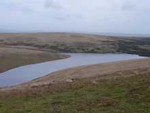

Over the course of the 19th and 20th centuries, several reservoirs and dams were built in the area now covered by Dartmoor National Park in Devon, England to supply drinking water to the rapidly growing towns in the surrounding lowlands. With its deep valleys and high rainfall, Dartmoor was an inevitable location. New reservoirs continued construction even after the establishment of the National Park in 1951.
Early schemes to use the moors as a source of drinking water involved the construction of water channels called leats. For example, Drake's Leat (completed 1591) took water to Plymouth and the Devonport Leat (1793) to the docks at Devonport. Rapid population growth of the seaside communities in the late 19th century and the birth of tourism required a significant improvement in quality and quantity of fresh water.
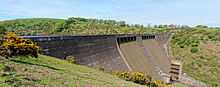
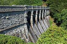
The first Dartmoor reservoir (Tottiford) opened in 1861 and heralded a busy era of dam construction which continued through to 1907, by which time the Dartmoor area was the site of five reservoirs. Three more were to follow during the course of the mid to late 20th century. A fourth, in the valley of the River Swincombe was rejected by the advisory committee of the County Council.[1]
A few long-established Dartmoor farms had to be abandoned and disappeared under the water as a result. During years of drought, some ruins can once again become visible. At Fernworthy, for example, low water levels often reveal the remains of Fernworthy Farm and a small granite Clapper bridge which once crossed the South Teign River. At the Avon reservoir, hut circles are visible at very low water levels.
Dartmoor reservoirs
| Point | Coordinates (Links to map resources) |
OS Grid Ref | Notes |
|---|---|---|---|
| Tottiford Reservoir | 50°38′10″N 3°40′59″W / 50.636°N 3.683°W | SX810832 | 1861, expanded 1865 |
| Kennick Reservoir | 50°38′49″N 3°41′38″W / 50.647°N 3.694°W | SX803843 | 1884 |
| Burrator Reservoir | 50°30′00″N 4°02′20″W / 50.500°N 4.039°WBurrator Reservoir) | SX554686 | 1898, expanded 1929 |
| Venford Reservoir | 50°31′26″N 3°51′22″W / 50.524°N 3.856°W | SX685709 | 1907 |
| Trenchford Reservoir | 50°37′48″N 3°41′28″W / 50.630°N 3.691°W | SX805824 | 1907 |
| Fernworthy reservoir | 50°38′28″N 3°53′20″W / 50.641°N 3.889°W | SX665840 | 1942 |
| Avon Dam Reservoir | 50°28′23″N 3°51′54″W / 50.473°N 3.865°W | SX677653 | 1957 |
| Meldon Reservoir | 50°42′11″N 4°02′24″W / 50.703°N 4.040°W | SX560912 | 1972 |
References
External links
| Wikimedia Commons has media related to Reservoirs of Dartmoor. |