Darreh Shahr
| Darreh Shahr دره شهر | |
|---|---|
| City | |
|
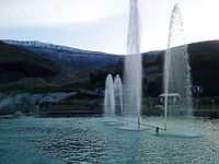
City view to the North | |
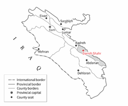 Location in the Ilam province | |
 Darreh Shahr Location in Iran | |
| Coordinates: 33°08′23″N 47°22′34″E / 33.13972°N 47.37611°ECoordinates: 33°08′23″N 47°22′34″E / 33.13972°N 47.37611°E | |
| Country |
|
| Province | Ilam |
| County | Darreh Shahr |
| District | Central |
| Government | |
| • Governor | Parviz Kowsarifar[1] |
| • Mayor | Mosadegh Taheri |
| • City Council |
Members of CC
|
| Area | |
| • City | 3.05 km2 (1.18 sq mi) |
| Elevation | 660 m (2,170 ft) |
| Highest elevation | 695 m (2,280 ft) |
| Lowest elevation | 635 m (2,083 ft) |
| Population (2011)[2] | |
| • Urban | 24,961 |
| Linguistics[3] | |
| • Language(s) | Persian, Kurdish |
| • Dialect(s) | Lori, Laki |
| Time zone | IRST (UTC+03:30) |
| • Summer (DST) | IRDT (UTC+04:30) |
| Postal code | 69611 to 69691 |
| Area code(s) | +98 84 3522 |
| ISO 3166 code | IR-05 |
| Vehicle registration | ٩٨ ط |
| UFI code | -3059816 |
| JOG reference | NI38-12 |
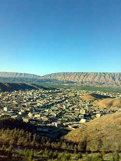
Darreh Shahr (Persian: دره شهر; also Romanized as Darreh-ye Shahr)[4] is a town and the capital of Darreh Shahr County, Ilam Province, Iran. It's situated in a wide valley in the northern hillsides of Kabir Kuh ranges. At the 2011 census, its population was reported 24,961. The ruined ancient city of Darreh Shahr Ancient City is located in the southern part of Darreh Shahr. It has been extensively excavated by archaeologists.[5] The Seymarah River flows to the north of the city. The city has a lot of potentials in agriculture, rich water supplies, green fields and dense forests.[6]
In ancient times Darreh Shahr has been the summer capital of Elam dynasty and it thrived on Sassanid Empire era.[7]
History
Ancient times
In ancient times, Elamites governed the Lorestan mountains and constructed several strong buildings. Darreh Shahr was the first Elamite city attacked and destroyed by Assyrians in addition to the massacre of people. In Seymareh Valley the remains of the Sassanid monuments are still present; hence Darreh Shahr might have been a thriving city in the Sassanid and the Parthian periods. Furthermore some foreign experts call the unearthed city as the second and lost capital of the Seleucids while some Iranian archaeologists believe that the monuments are part of the state of Sirvan. Referencing some resources and texts, Darreh Shahr may be the same as Mehr Jaan Ghazagh, Saabzaan, Seymareh or the city of Khosrau II in the late Sassanid period completely leveled to earth from an earthquake in the years 248 and 344 A.H.[8]
Despite the fact that there is no strong and reliable evidence to show the first time human being settled in this are, most historians believe that Madakto Ancient City as a city in Sassanid era and because of its proximity to Ctesiphon was in fact a summer capital for kings in that era. Historians also believe the city was founded by Khosrau II. The great and impregnable fortress in east of Ctesiphon mountains that Khosrau II built to protect his family when threatened is believed to be in Darreh Shahr as well.[9]
Hormozan, a ruling king of Sassanid era was from Mehrgan Kade. The city gained its popularity again in Islamic era and was known as Seymareh.[10] There are several archaeological sites round the city that are clear evidences of the importance of this city in ancient times: Bahram Choobin Gorge, Darreh Shahr Fire Temple, Gavmishan Bridge, Jam Namesht Bridge, Koozeh Garan Hill, Majeen Ancient City, Majeen Gorge, Sassanid Bridge, Sheikh Makan Fort and Tikhan Hill.
Recent history
This part of Ilam Province was officially declared county in 1343 SH (1964-1965). The county has three districts, Central, Badreh and Majin. Darreh Shahr is in Central district.[11]
Name appellation
The name of Darreh Shahr may be derived from the name of Seymarah River which its name is Ghamasyab before it crosses the Ilam Province borders and is Seymarah when comes into the province. It's been said that because Darreh Shahr is near the Saymarah River and is located in one the Kabir Kuh valleys so it is called Darreh Shahr which means 'City Vally'.[12]
Geography
Darreh Shahr is situated at the transition zone between Kabir Kuh foothills and Seymareh River and alongside Darreh Shahr River which flows from Sarab-e Darreh Shahr to Seymareh river through the town. The town lies within the foothills of eastern side of Kabir Kuh. Darreh Shahr elevation is approximately 660 m (2,170 ft) above sea level downtown. The city covers a land of 3.05 km2 (1.18 sq mi).
Climate
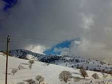
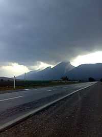
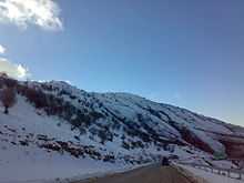
Darreh Shahr experiences cold winters and hot summers.[13] Due to being in Subtropical high pressure zone Ilam province including Darreh Shahr experiences a relatively static thermal condition but proximity to large deserts like Arabian Desert and Iraqi Desert brings several heat waves in summers. However, mediterranean and Sudan low pressure air masses bring intense precipitation and thundershowers in winters. The temperature in winters goes down even to −5 °C (23 °F) and rises to maximum temperature of 42 °C (108 °F) in summers. The long-term average annual precipitation is about 460 mm (18 in).[14][15]
| Climate data for Darreh Shahr | |||||||||||||
|---|---|---|---|---|---|---|---|---|---|---|---|---|---|
| Month | Jan | Feb | Mar | Apr | May | Jun | Jul | Aug | Sep | Oct | Nov | Dec | Year |
| Record high °C (°F) | 20.8 (69.4) |
25.6 (78.1) |
29.6 (85.3) |
34.4 (93.9) |
42.2 (108) |
46.6 (115.9) |
49 (120) |
48.8 (119.8) |
46.6 (115.9) |
38.4 (101.1) |
30.2 (86.4) |
25.6 (78.1) |
49 (120) |
| Average high °C (°F) | 9.9 (49.8) |
12.1 (53.8) |
17.0 (62.6) |
22.7 (72.9) |
28.2 (82.8) |
35.2 (95.4) |
39.0 (102.2) |
39.1 (102.4) |
33.9 (93) |
26.8 (80.2) |
18.2 (64.8) |
11.9 (53.4) |
21.2 (70.2) |
| Daily mean °C (°F) | 9.0 (48.2) |
10.5 (50.9) |
14.8 (58.6) |
20.8 (69.4) |
28.1 (82.6) |
35.6 (96.1) |
38.4 (101.1) |
37.1 (98.8) |
32.3 (90.1) |
24.0 (75.2) |
13.2 (55.8) |
10.4 (50.7) |
22.85 (73.13) |
| Average low °C (°F) | −1.2 (29.8) |
1.1 (34) |
4.1 (39.4) |
7.9 (46.2) |
11.8 (53.2) |
16.0 (60.8) |
19.9 (67.8) |
20.1 (68.2) |
14.2 (57.6) |
9.9 (49.8) |
5.0 (41) |
1.1 (34) |
9.05 (48.29) |
| Record low °C (°F) | −4.4 (24.1) |
−3.4 (25.9) |
0.8 (33.4) |
−2.6 (27.3) |
8.8 (47.8) |
10.8 (51.4) |
20.0 (68) |
21.6 (70.9) |
12.0 (53.6) |
6.0 (42.8) |
−1.4 (29.5) |
−3.2 (26.2) |
−4.4 (24.1) |
| Average precipitation mm (inches) | 69.5 (2.736) |
72.0 (2.835) |
49.2 (1.937) |
55.9 (2.201) |
11.4 (0.449) |
0.2 (0.008) |
0.1 (0.004) |
0.1 (0.004) |
1.0 (0.039) |
25.5 (1.004) |
56.9 (2.24) |
60.2 (2.37) |
402 (15.827) |
| Avg. precipitation days (≥ 1.0 mm) | 9. | 9.4 | 10.1 | 8.7 | 3.9 | 0.4 | 0.3 | 0.1 | 0.0 | 3.1 | 6.3 | 8.2 | 59.5 |
| Average relative humidity (%) | 59 | 66 | 55 | 37 | 34 | 20 | 21 | 23 | 27 | 31 | 63 | 67 | 41.9 |
| Mean monthly sunshine hours | 188.9 | 178.8 | 187.5 | 224.6 | 260.4 | 316.4 | 313.8 | 323.1 | 262.9 | 286.9 | 199.8 | 224.5 | 2,967.6 |
| Source: I.R. of Iran Meteorological Organization | |||||||||||||
Flora and fauna
Flora
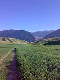
Numerous plant and animal species are found around Darreh Shahr. About 1,000 plant species exist in mountainous regions around the city. Approximately 30% of these species has pharmaceutical and nutritious value.[16] Along the Zagros range, the forest is more impoverished and a rich steppe flora develops among the trees. Forest remnants consist primarily of Quercus persica and, up to an elevation of 2,400 m (7,900 ft), xerophilous forest of Quercus spp., hawthorn (Crataegus), almond (Prunus amygdalus), nettle tree (Celtis) and pear (Pyrus spp) predominates. Below 1,400 m (4,600 ft), the vegetation is steppic, with shrubs predominating.[17]
Funa
The Zagros Mountains have traditionally supported a rich variety of animal life, including brown bear (Ursus arctos), the Asiatic black bear (U. thibetanus), eagles (Aquila spp.), wild goats (Capra aegrarus), sheep (Ovis orientalis), wolves (Canis lupus), leopard (Panthera pardus) and other wild cats. Five taxa of lizards are endemic to the Zagros range.[17]
Other species that have been recorded in the southwestern part of Zagros ranges like Darreh Shahr include jackal (C. aureus), fox (Vulpes vulpes), marten (martes foina), mongoose (Herpestes ichneumon), striped hyaena (Hyaena hyaena), jungle cat (Felis chaus) and wild pig (Sus scrofa). In areas of semi-arid steppe, typical avifauna includes rock partridges (Alectoris chukar and A. graeca), see-see partridge (Ammoperdix griseogularis), little bustard (Tetrax tetrax), houbara bustard (Chlamydotis undulata), black-bellied sandgrouse (Pterocles orientalis) and black vulture (Aegypius monachus).[17]
Economy
Darreh Shahr economy is mainly based on agriculture, orchards and ranching. Water for agriculture purposes is supplied from wells, springs and rivers. Agricultural products include: wheat, barley, cucumber, cantaloupe, honeydew, watermelon, legume, corn, fodder, rice, sesame, vegetables, walnut, pomegranate, grape, apple and fig.[18]
Darreh Shahr Industrial Park is located 11 km (6.8 mi) out of the city along the Darreh Shahr-Pol-e Dokhtar road.There are still 17 small industries in the park.[19]
Carpentry
Handicraft is the main industry in Ilam province included Darreh Shahr.[7] "Ilam carpet is one of the most distinguished carpets of our country." Alikhani, head of Iranian National Carpet Company said addressing the head of Ilam Industry, Mine and Trade Organization.[20]
"Ilam includes top provinces in terms of the number of weavers. Its carpet is of optimum condition that is going to be developed more than ever by more protection."[20] "Ilam carpet has a historic precedence and favorable capacities." Head of Ilam Industry, Mine and Trade Organization said.[20]
The main handicraft products are hand-made rugs and carpets. Darreh Shahr county has about 2,000 active weavers and they annually create about 1,200 m2 (13,000 sq ft) rugs and hand-made carpets.[21]
Attractions
Most of the town's attractions are historical sites and natural locations around the town.
Darreh Shahr Ancient City
Darreh Shahr Ancient City is located in southeastern part of the present Darreh Shahr. It is among the largest historical sites in Ilam province. It is about 200 acres and is one of the first places registered on National Historical Places of Iran. It belongs to Sassanids era. There are remains of buildings, walls, fortresses and bazaars in the area. Walls mostly consist of stone, concrete and plaster. based on the shape of buildings, materials and earthenwares in and around the area, Darreh Shahr Ancient City belongs to late Sassanid era.[22]
Darreh Shahr Ancient City was destroyed on 334 AH (945-946) due to a devastating earthquake.[22]
Bahram-e Chobineh Gorge
This narrow and high valley is one of the most important and strategic points of the region, located in the western side of the Dareh Shahr - Pol Dokhtar road. This gorge, which is also called the Bahram Hunting Ground, contains several historical monuments in its entrance and on the hard rocks like the ruins of a Sassanide castle which is built of stone and gypsum with stone stairs and four connected water reservoirs (Ab anbar) which are worth seeing.[23]
Darreh Shahr Fire Temple
There is a fire-temple in the city of Darreh Shahr which is a four-arched building which is locally called Taaq. Originally the building was constructed by rubble stone and gypsum, and has recently been repaired.[23]
Sheikh Makan Fort
Located 6 kilometers southeast of Darreh Shahr, the ruins of this fort can be seen in the entrance of the village with the same name with 150 years of antiquity. Construction materials indicate that it belongs to the Qajar period. The walls of the fort are delicately made of stone and gypsum. There is also the remains of a water mill.[23]
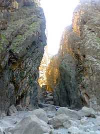
Majeen Gorge
There are many crevices and caves one of them is known as the Kulkani Cave. The entrance of the cave is 30 meters long and there is a small pond built of stone and Sarouj (plaster of lime and ashes or sands). In addition, there are 12 other caves similar to the dwellings of pre-historic men. Some vestiges like earthenware pieces and other objects belonging to the mid 1st millennium BC have been discovered in this cave.[24]
Seymareh River
This long and large river, which is called Karkheh in the lower part, flows through the eastern margin of the province. Its main streams are Gamasiab, Qara Sou, Chenareh, Kashkan and another stream that originates from Kamyaran and Mahidash heights.[23]
Gavmishan Bridge
Located in the south of Darreh Shahr, in the beginning of a gorge with the same name on the outskirts of Kabir Kuh, is an ancient bridge called Gavmishan with 3 arches that has been recently repaired (as of 2008). Each of its arches is placed at 5.5 m (18 ft) intervals from each other.[8] This Sassanide bridge has been constructed in the confluence of the Seymareh and Kashkan rivers. Although it has been repaired several times during the past, it is almost in a ruined state now.[23]
Imamzadeh Saleh
This Imamzadeh is located in Majeen Graveyard around Darreh Shahr. This quadrangular and two story building has a pyramid shaped dome. The main tomb is located in the first floor which is totally made up of brick with a herringbone arch. In the second floor, there is a tomb covered with stone, gypsum and earthenware. Its antiquity dates back to the 8th century AH. and needs some repair. Interior plaster works of the Imamzadeh are unique and counted as worthy vestiges of this period.[23]
Baba Seifedin Mausoleum
Baba Seifedin Mausoleum in located in the north east of Darreh Shahr in the outskirts of a hill known as Chahar Taq. There are two tombs in the mausoleum without any description on the tombstones. There is a small inscription on the top of the entrance door which indicates the date of its repair. The materials of the building are stone, gypsum and brick. There are several trees around the mausoleum which are hundreds of years old.[23]
Infrastructure
Transportation
Darreh Shahr Terminal in the city's north is the main passengers terminal. It provides daily services to Pol Dokhtar, Dezful, Andimeshk, Abdanan and Ilam by car. In the past services were generally provided by minibuses. Darreh Shahr Bus Terminal provides daily service to Tehran also.
The city has no inland navigable waterways. An emergency airstrip exists in the south of the city. However, it is used for agricultural aircraft only.
Darreh Shahr-Ilam route
The city is connected to neighboring towns, Ilam, Pol Dokhtar and Abdanan by three main roads. The Darreh Shahr-Ilam route has undergone development projects. Since the beginning of the project about 62 km (39 mi) have been turned into 2+1 highway with reversible lane. The state government has spent $21M so far and it requires $35M more to finish the project.[26]
Kabir Kuh tunnel
The Darreh Shahr-Abdanan road which goes over the Kabir Kuh heights has many tight turns and makes it very difficult to pass in the winters. The Kabir Kuh Tunnel project is undertaking in both sides of the Kabir Kuh ranges to build a tunnel under and bypass the current connecting route. Only 350 m (1,150 ft) has been dug so far in both sides. The tunnel is going to be 4,600 m (15,100 ft) in length.[25][27]
Health care
Valiasr Hospital, founded in 1983 with 96 beds is the major hospital in the city. However, currently only 20 beds are ready and in service. There are some other medical centers such as Taleghani Medical Center located in Taleghani neighborhood. All medical centers are overseen by Darreh Shahr County Medical Office, supervised by Medical University of Ilam.[28]
References
| Wikimedia Commons has media related to Darreh Shahr. |
- ↑ "پرتال فرمانداری شهرستان دره شهر". فرمانداری شهرستان دره شهر. Retrieved 27 July 2013.
- ↑ "مرکز آمار ایران". مرکز آمار ایران. Retrieved 23 July 2013.
- ↑ "جاذبه های شهرستان دره شهر". Retrieved 29 July 2013.
- ↑ Darreh Shahr can be found at GEOnet Names Server, at this link, by opening the Advanced Search box, entering "-3059816" in the "Unique Feature Id" form, and clicking on "Search Database".
- ↑ Iran: journal of the British Institute of Persian Studies. The Institute. 1998. Retrieved 7 September 2011.
- ↑ http://www.lakestan.ir/index.php?option=com_content&task=view&id=76&Itemid=84
- ↑ 7.0 7.1 اطلس ایران وجهان. "دانستنیها ی تاریخ وجغرافیایی ایران وجهان".
- ↑ 8.0 8.1 "Dareh Shahr, the summer capital of Elamites". tehrantimes.com. Tehran, Iran: Tehran Times. 20 April 2013. Retrieved 13 June 2014.
- ↑ Rawlinson, Sir Henry (1839). "Notes on a March from Zoháb, at the Foot of Zagros, along the Mountains to Khúzistán (Susiana), and from Thence Through the Province of Luristan to Kirmánsháh, in the Year 1836". The Journal of Royal Geographical Society 9. Retrieved 25 July 2013.
- ↑ ایزدپناه, حمید (1998). تاریخ جغرافیایی واجتماعی لرستان (مقدمه ای بر آثار باستانی وتاریخی لرستان). انجمن آثار و مفاخر ملی آیران.
- ↑ "آشنایی با شهرستان دره شهر". فرمانداری دره شهر. Retrieved 27 July 2013.
- ↑ "ایرانگردی-گردشگری-نقشه-ایران-تور-سفر - شهرستان دره شهر".
- ↑ "اقلیم استان ایلام". Retrieved 26 July 2013.
- ↑ http://www.ilammet.ir/geo.asp
- ↑ گزارش بارندگی ۲۴ ساعت گذشته ایستگاه های هواشناسی استان (PDF). ilammet.ir/ (in Persian). اداره کل هواشناسی استان ایلام. 2014. p. 1. Retrieved 6 June 2014.
- ↑ "ايلام در يك نگاه". اداره كل حفاظت حفاظت محيط زيست استان ايلام. Retrieved 26 July 2013.
- ↑ 17.0 17.1 17.2 Fund, W. "Zagros Mountains forest steppe". Retrieved 26 July 2013.
- ↑ "جاذبه هاش شهرستان دره شهر". Retrieved 26 July 2013.
- ↑ "شهرک صنعتی دره شهر". Retrieved 26 July 2013.
- ↑ 20.0 20.1 20.2 Administrator. "Ilam Carpet, One of the Most Distinguished Carpets".
- ↑ ".:: www.ilamToday.com .::. ايلام امروز ::.".
- ↑ 22.0 22.1 "اماکن زیارتی، تفریحی و جاذبه های گردشگری درهشهر". Retrieved 27 July 2013.
- ↑ 23.0 23.1 23.2 23.3 23.4 23.5 23.6 "Dareh Shahr tourism attractions". Iran Tourism & Touring Online. Iran Tourism & Touring Online Website. Retrieved 28 July 2013.
- ↑ "Majeen Gorge, Dareh Shahr". www.irantouronline.com. Iran Tour Online. 1 January 2008. Retrieved 13 June 2014.
- ↑ 25.0 25.1 روابطعمومي ادارهكل راه و شهرسازي استان ايلام. "200 متر از تونل كبيركوه در مسير آبدانان- دره شهر استان ايلام حفاري شد". I.R. of Iran Road Maintenance and Transportation Organization website. Retrieved 27 December 2013.
- ↑ "استاندار ايلام از پروژه هاي راهسازي ايلام- دره شهر بازدید کرد". ilamefarda. ilamefarda.ir. Retrieved 27 December 2013.
- ↑ از سر گرفته شدن عملیات اجرایی تونل کبیرکوه. yjc.ir (in Persian). 9 April 2014. Retrieved 6 June 2014.
- ↑ "مشخصات بیمارستانهای استان ایلام". سایت تخصصی بیمارستان سازی در ایران. hospital-ir.com. Retrieved 20 January 2014.
| |||||||||||||||||||||||||||||||||||||||||||||||||||||||
| ||||||||||||||||||||||||||||||||||||||||||||